The first Northeast Passage traverse ever for the Silver Explorer, this is your chance to become the polar pioneer you have always dreamed of becoming. Retrace the voyages of famous explorers Nordenskiöld, Nansen, DeLong, and Amundsen and travel as far north as the ice lets you. A wealth of wildlife, geological, and cultural experiences awaits, while visits to local villagers warm your soul.
Highlights
Visit one of Russia’s most famous lighthouses & the monument of Dezhnev
Explore Wrangel Island, a UNESCO World Heritage Site rich in history
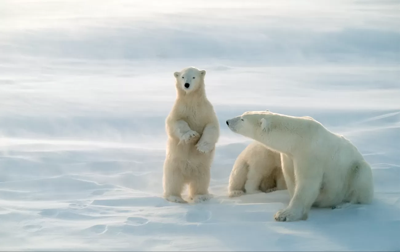
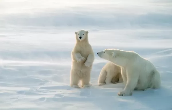
Admire wildlife including walrus, musk oxen, and possibly even polar bears
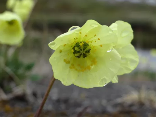
Discover the diverse and beautiful vegetation on tundra nature walks
Involves minimal physical effort and is typically associated with leisurely activities. Activities are low-intensity or last less than a few hours each day.
Nome is located on the edge of the Bering Sea, on the southwest side of the Seward Peninsula. Unlike other towns which are named for explorers, heroes, or politicians, Nome was named as a result of a 50-year-old spelling error. In the 1850s an officer on a British ship off the coast of Alaska noted on a manuscript map that a nearby prominent point was not identified. He wrote "? Name" next to the point. When the map was recopied, another draftsman thought that the “?” was a C and that the “a” in "Name" was an o, and thus Nome was christened...
Day 2: Cross the International Date Line - Lose a Day
Provideniya is a former Soviet military port at the southern limit of the Arctic ice pack. With slightly less than 2000 inhabitants, many of whom are Yupik, it is the largest town and administrative center of the Providensky District. Started as a depot for the Northeast Passage traffic, it now is a port of entry to the Russian Far East and since the decline of the Soviet Union eco-tourism has boosted the local economy. The town has a Technical School and a fascinating museum with interesting and well-presented exhibits about the natural history and wildlife of the region.
Located between the Chuchki Sea and the Bering Sea, Cape Dezhnev comprises the easternmost mainland point in all of Eurasia. The cape was originally named East Cape by Captail James Cook, but has since been renamed for Semyon Dezhnev, the first recorded European to round its peninsula. The cape is the edge of a rocky headland with steep, carved-looking cliffs. Ashore can be found one of Russia’s most famous lighthouses and the monument honoring Dezhnev. The cape was a center for trade between American and European whalers, as well as fur traders.
Located north of Cape Dezhnev in Chukotka along the Bering Strait, the small coastal village of Uelen is the furthest east settlement in all of Eurasia (and is also the closest Russian settlement to the United States). The village is near the Uelen Lagoon and is known by the local Yupik as “Land’s End,” and has a population of around 700 inhabitants. When during soviet times it had been decided to abandon many of the smaller settlements in favor of larger consolidated ones, Uelen was chosen as one of the four villages to take in the inhabitants of other settlements.
Kolyuchin Island is a small island in the Chukchi Sea that is uninhabited and covered with tundra vegetation. The island is the site of a famous rescue operation after a Russian icebreaker was crushed by ice nearby. Located close to the Siberian shore, this island has been used as the base for a now-abandoned meteorological station at its western end, while walrus hunters had a few huts on the eastern side. The island has steep, dramatic bird cliffs teeming with pelagic cormorants, thick-billed murres, and kittiwakes.
Krasin Bay is one of several landing points to explore Wrangel Island, a UNESCO World Heritage Site rich with Arctic vistas and wildlife. Most noteworthy that can be seen from Krasin Bay are the remains of ancient inhabitants of Wrangel Island, a 3,400 year old Paleo-Eskimo camp. In addition, nature trekking to look for land mammals, birds, and the varied flora is recommended. Wildlife sightings may include walrus, musk oxen, and possibly even polar bears.
Day 7: Cape Waring, Wrangell Island | Ostrov Gerald
Cape Waring is a dramatic approach to Wrangel Island, an important nature reserve on the Chukchi Sea and a UNESCO World Heritage Site known for its Arctic beauty and diverse wildlife and flora. Sail between blue and white ice floes, approaching a rocky cliff covered in seabirds and hugged by low-lying clouds. The ice floes are a favorite hang-out spot for walrus as well as seabirds such as Brunnich’s guillemots (thick-billed murres), petite and hearty black-and-white water birds.
Ostrov Gerald is a small, isolated granitic island in the Chukchi Sea, less than 40 nautical miles to the east of Wrangel Island. It was named after a survey vessel, the HMS Herald, which visited the island in 1849 while searching for the vanished expedition of Sir John Franklin, and its English name is in fact, Herald Island. Steep cliffs ring the island in all but one slim area of accessible shoreline at the northwestern point of the island. Here the cliffs have eroded into piles of rock and one can find the only possible landing spot on this unglaciated, remote, and uninhabited island
Day 8: Ushakova Cape, Wrangell Island | Cape Florens, Wrangell Island
Located in the Arctic Ocean between the Chukchi Sea and East Siberian Sea, Wrangel Island is worth a longer visit to experience the Arctic wildlife that resides here. This protected nature area and UNESCO World Heritage Site has the largest amount of polar bears and apparently was the last place where woolly mammoth roamed. The name of the island goes back to the search for land north of the Chukchi Peninsula by Ferdinand von Wrangel, who went in search of the island with coordinates but did not find it on his first expedition.
Cape Florens is located on the less icy northeast edge of Wrangel Island. This bay offers access to tundra nature walks, where visitors tread upon permafrost and are able to explore the diverse and beautiful vegetation, including shrubs, sedges, grasses, mosses, and lichens. This protected nature area and UNESCO World Heritage Site has a large amount of polar bears, which might be spotted if the timing is right. In addition to the tundra flora, visitors coming to the island from this entry point may see two types of lemmings found on Wrangel, starkly white arctic foxes, and beautiful snowy landscapes.
While at sea, enjoy wine tastings, designer boutiques, language, and dance classes. Take in a matinee movie, check the market or your e-mail in the Internet Point, slip away with a novel from the library to a sunny chaise or with a movie to your suite. Or just take in the sun pool-side.
Ayon Island is located off the coast of Chukotka at the eastern end of the Kolyma Gulf. Its size of 2,000 square kilometers permits the small local Chukchi population to herd reindeer. The local population welcomes the rare visitor with warmth and hospitality. The village of Ayon has a school with a museum that was put together by the children of the school. Displayed are mammoth tusks, stuffed birds, and some Paleo Eskimo artifacts. The Russian polar station on Ayon Island is one of the few meteorological stations still in use and is staffed by 12.
Also known as Bear Islands, the Medvezhyi are an uninhabited group of islands at the western side of the Gulf of Kolyma in the East Siberian Sea. It is not so much the bears, but the flora and geology that make these six islands stand out. This is a commercial fishing area despite the existence of fast ice that surrounds the islands during much of the year. On Chetyrokstolbovoy Island, flowers, lichen, mosses and mushrooms are abundant. Visitors that alight on Chetyrokstolbovoy (also known as Four-spires Island because of its rock formations) can visit an abandoned weather station.
Ostrov Bennetta in Russian, or Bennett Island as it is known in English, is the largest of the De Long group of islands located in the northern extents of the East Siberian Sea. Mount De Long dominates Bennett Island and is the highest point in the archipelago topping 426 meters (1,398 feet). The frosty white landscape of Bennett Island is the largest permanent ice cover within the De Long Islands. In recent years scientists have been able to map four separate glaciers forming the solid ice cap of this island.
Akhmatov Gulf is also known as Akhmatov Bay and Akhmatov Fjord. It is a deep, glacially carved arm that runs almost mid-way through the mass of Bolshevik Island, the southernmost island of Severnaya Zemlya in far northern Russia. The fjord has a wide mouth (approx. 9 nautical miles across) on the island’s northeastern side and is clogged by ice much of the year. Steep, ice-polished mountain slopes drop into the water on either side of the broad channel. The gulf extends inland for just over 30 nautical miles.
Isachenko is an island of the Kirov group in the Kara Sea north of Russia. A level beach, under the right conditions, can provide a landing site for access to this remote island. Ashore, it is possible to see a deserted station, the operation of which was likely discontinued in 1993. Evidence of the station’s abandonment is everywhere with scattered pieces of equipment and a host of other materials left behind by the station crew in the now slowly decaying huts. The shoreline is a thriving intertidal zone where clams bury down into the soft sand and sponges thrive on mussel shells.
Uyedineniya Island, Lonely Island, or Solitude Island, as it is also known, is located in the Kara Sea between Novaya Zemlya and Severnaya Zemlya. The small, relatively flat island’s tundra, when free of ice and snow, grows green vegetation in the summer. In addition to tundra, there are bogs and small lakes on the island. A long spit of land dominates its northeastern side and ice floes are commonly found in the waters here, even in the summer.
Day 19: Cape Zhelaniya, Novo Zemlya | Ostrov Oranskiye
The Russian word, Zhelaniya means 'wish,' and leads one to wonder why such a poetic name was ascribed to this remote headland on the northern end of Severny Island, part of Novaya Zemlya in the Russian Federation. The cape is an important geographical landmark although quite a desolate and exposed location, especially in the bitter Arctic winters. It is the physical point of reference that marks the boundary between the Barents Sea and the Kara Sea.
Located a few nautical miles north of Cape Zhelaniya at the northern tip of the massive island of Novaya Zemlya lies tiny Ostrov Oranskiye, one of a small group known as the Orange Islands. Willem Barentz, a Dutch navigator, sailed this region in the late 1500s on the small ship Mercury. The Mercury was one of three ships attempting to enter the Kara Sea in order to find the Northeast Passage above Siberia. It is reported that the Mercury’s crew discovered a massive herd of walrus on the Orange Islands and proceeded to attack them with hatchets and pikes to harvest their fabulous ivory tusks.
Over 190 islands complete the Franz Josef Land group, covering an area of more than 16,000 square kilometers. Hall Island is one of many islands in the archipelago that is almost totally covered by glaciers. Its highest point is over 500 meters, and is located on top of an ice dome. Cape Tegetthoff is a headland on the south end of Hall Island, one of the largest islands in the Franz Josef Land group. Hall Island was named after American Arctic explorer Charles Francis Hall.
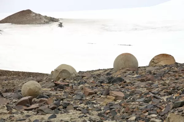
In the Franz Josef Land archipelago, an estimated 85% of the islands are glaciated. Champ Island is ice capped as well, but probably best-known by the few people who have had the opportunity to visit, for its rounded stone geodes, an almost unique phenomenon, even on a world-wide scale. At Cape Triest numerous geodes are partly stuck in the crumbing rock faces. A geode is sedimentary in origin, and is essentially a hollow, spherical mass of mineral matter that often forms with crystals in the center.
Hooker Island is located in the heart of the Franz Josef Land archipelago, deep in the Arctic Ocean. A small bay provides an anchorage that can be busy with seabirds from nearby bird cliffs. Rubini Rock in Tikhaya Bay is an impressive rock formation with an intricate surface structure of curved basalt columns. Stark color contrasts are enhanced by bright lichens and lush green summer vegetation in less steep parts of the island. On Hooker Island one can encounter dramatic bird cliffs.
The Franz Josef Land archipelago was first spotted by Norwegian sealers in 1865. The climate is severe most of the year with the average summer temperature around 35° F (2° C). Sparsely vegetated by lichens, mosses, and a few species of Arctic flowering plants, islands like Bell Island can be home to mammals including polar bears and the arctic fox, with the potential for numerous seabird species to be nesting on the island. Bell Island is located in the western portion of the island chain and is home to the historic hut of explorer Benjamin Leigh Smith, dating back to 1881.
In the remote Arctic Ocean, between the Barents Sea and Kara Sea, lie the islands of Franz Josef Land. Nagurskoye is an Arctic airfield located within these islands 1350 km north of Murmansk that was built in the 1950s. Likely purposed originally as a staging base for Soviet Long Range Aviation bombers to reach the US, it was maintained by the Russian Air Force agency OGA (Arctic Control Group). For modern expeditions into the distant archipelago of Franz Josef Land, the base serves as a point of entry and/or exit with clearance procedures taking place here.
The last city founded by the Russian Empire, Murmansk has long been an important ice-free naval and commercial shipping port. The smoke stacks, port cranes, and Soviet-era architecture are unappealing, but the natural surroundings draw visitors to ski and snowmobile in winter, and in summer to fish the thousands of lakes and rivers, and party away the long, light nights.
Tromsø surprised visitors in the 1800s: they thought it very sophisticated and cultured for being so close to the North Pole—hence its nickname, the Paris of the North. It looks the way a polar town should—with ice-capped mountain ridges and jagged architecture that is an echo of the peaks. The midnight sun shines from May 21 to July 21, and it is said that the northern lights decorate the night skies over Tromsø more than over any other city in Norway.
Apologies for the inconvenience. Prices for not yet published. Below per person rate based on previous season. Contact us to confirm upcoming season pricing.
Prices for are estimated based on inflation. Contact us to confirm pricing and availability for your desired departure date.
$30,960
Rates are dynamic and fluctuate based on capacity. Contact us for a specific quote.
Select a Date
Adventurer Class
6 cabins on Deck 3, 180 sq. feet, Twin or Queen beds, 2 portholes.
Select a Date
Explorer Class
4 cabins on Deck 4, Twin or Queen beds, 180 sq. feet with view window.
Select a Date
View Suite
12 suites on Deck 3, 230 sq. feet with view window, Twin or Queen beds.
Select a Date
Vista Suite
16 suites on Deck 4, 194 - 230 sq. feet with large window, Twin or Queen beds.
Select a Date
Veranda Suite
8 suites on Deck 5, 215 sq. feet with French balcony, Twin or Queen beds.
Select a Date
Medallion Suite
2 suites on Deck 7, 358 sq. feet with private veranda, Twin or Queen beds.
Select a Date
Silver Suite
6 suites on Deck 5, 430 sq. feet with 2 French balconies, Twin or Queen beds.
Select a Date
Grand Suite
2 suites on Deck 7, 650 sq. feet with large private veranda, Twin or Queen beds.
Select a Date
Owner
2 suites on Deck 7, 540 sq. feet with large private veranda, Twin or Queen beds.
Notes
Please note: Fares are capacity controlled, and subject to change at any time without notice. All prices are in US dollars, cruise-only per person based on double occupancy.
- The supplement for single occupancy in a Vista, Veranda or Midship Veranda Suite ranges from 25% – 100% above the double occupancy fare, depending upon the sailing and suite selected. Single supplement for a Silver or Medallion Suite (Silver Shadow and Silver Whisper), Owner’s, Grand or Royal Suites are 100% above of the double occupancy fare. Suites for single and third guests are capacity controlled.
This was my first experience with Adventure Life - and I couldn't have been more pleased with the trip. The guides and local staff in both Buenos Aires and Uruguay were terrific - extremely helpful and accommodating. I really enjoyed meeting the friendly staff in Buenos Aires in person (I left my bags with them for the afternoon).
Karen Snider
TrustScore 4.8 | 169 reviews
TrustScore 4.8 of 5
Based on 169 reviews on
32 minutes ago
Friendly and professional interactions. Answered my questions and followed up on initial contact.
Tim Elliott
1 day ago
Adventure Life has been an extraordinary travel resource for us over the years and today was no exception. Our River Cruise booking was handled by Jess (who has been our personal trip planner for several years) the same day as our inquiry. Suggestions were given for cabin choice and pre-trip options (that were not shown on the cruise line's website) like airport transfers and prepaid gratuities. Trip insurance recommendations followed and we were assigned a travel co-ordinator till the end of the tour. All we have to do is show up! Great service from friendly folks.
APtravelwell
2 days ago
My representative Kevin was very responsive generally and in crafting our itinerary to our specific priorities.
Rocco Labella
2 days ago
Although there was a lot of paper work, I received help and guidance when I needed it.
Donna Kirby
3 days ago
Our travel was flawless! The rider pickup (airport, hotel, ship) was seamless. Jane's recommendation for Emerald Cruise Sakara was everything I wanted but the experience was soooo much more. Adventure Life took care of each and every detail and this was the easiest of all my travels.