Chile’s extensive coastline enables it to host every climatic zone imaginable, ranging from desert yet moderate in the north to the Mediterranean in the middle to oceanic and chilly in the Andes. Understanding Chile's weather patterns helps travelers plan the perfect trip to this diverse South American destination.
Chile Climate Overview
Chile has a landmass smaller than any other South American republic except Ecuador, but its long coastline (2,700 miles / 4,300 km) makes it feel vast. The country is never more than 100 miles (180 km) wide, with the towering Andes Mountains forming its eastern border. In some regions, the Andean peaks are visible directly from Pacific beaches.
Climate Regions of Chile
- Northern Chile: Home to the Atacama Desert, one of the driest places on Earth
- Central Chile: Mediterranean climate with warm summers and mild winters
- Southern Chile: Cooler, wetter climate with lakes, fjords, and glaciers
- Patagonia & Far South: Windy, cold, and dramatic landscapes near Antarctica
From desert plains to glaciers, the
climate of Chile is one of the most diverse in the world.
What Is the Weather Like in Chile Year-Round?
Chile’s climate varies greatly by region, but it is generally pleasant year-round.
- Northern & Central Chile: Warmest from November–February
- Southern Chile & Patagonia: Warmest from January–March
- Summer: Can be hot and dry, especially in the north
- Winter: Colder in the south, mild in central regions
Average Temperatures by Region
- Santiago:
- Summer highs: 82°F (27–28°C)
- Winter lows: 56°F (13°C)
- Central Chile:
- Summer: 82°F (28°C)
- Winter: 57°F (14°C)
- Southern Chile:
- Winter: 55°F (13°C)
- Summer: 61°F (16°C)
As you travel farther south, temperatures drop significantly. Visitors heading to Patagonia or Antarctica should pack warm, weatherproof layers.
Atacama Desert Weather
Explore the surreal Valley of the Moon
The Atacama Desert dominates northern Chile and includes towns such as Tarapacá and Antofagasta. Despite its arid climate and tropical latitude, it remains temperate thanks to the cold Humboldt Current along the Pacific coast.
Atacama Climate Highlights:
- One of the driest places on Earth
- Large temperature swings between day and night
- Occasional wildflower blooms after rare rain events
- Coastal fogs known as camanchaca
Best Time to Visit the Atacama Desert
- Peak Season: December–February
- Best for Stargazing: June–August
Although it’s a desert, temperatures drop sharply at night. Visitors should pack:
- Jackets and sweaters
- Long pants
- Gloves and hats
Winter months offer some of the clearest night skies on Earth, making this region world-famous for astronomy.
Average Temperatures in Chile
(Keyword focus: average temperatures + Chile weather)
- Santiago: 45°F–86°F (7°C–30°C)
- Atacama Desert: 32°F–77°F (0°C–25°C)
- Patagonia: 28°F–64°F (-2°C–18°C)
Temperatures vary dramatically depending on elevation and latitude.
Santiago & Surrounding Vineyards
See the weather in Santiago
This central region is Chile’s agricultural heartland and enjoys a Mediterranean climate.
- Summer highs: 82°F (28°C)
- Winter lows: 38–50°F (3–10°C)
- Rainy season: May–August
Best Time to Visit Santiago
- Late November–March: Warm, dry weather
- March–May: Ideal for wine harvest season
Santiago Chile weather is typically dry and sunny in summer, while winters are cooler and partly cloudy. Evenings can be chilly year-round.
Lake District Weather
See the weather in Puerto Montt
Chile’s Lake District features snowcapped volcanoes, lush forests, and glacial lakes.
- Climate similar to the U.S. Pacific Northwest
- Mild summers, cool and rainy winters
- Popular for hiking, boating, and skiing
Average Temperatures:
- Summer: 57°F (14°C)
- Winter: 45°F (7°C)
Snowfall is common in winter, making it a popular ski destination.
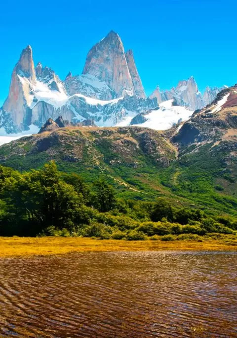
Patagonia Weather
See weather in Punta Arenas | Puerto Natales | Ushuaia
Patagonia covers nearly 30% of Chile’s landmass and is known for dramatic landscapes and unpredictable weather.
Patagonia Climate Notes:
- Strong winds year-round
- Cool summers, cold winters
- Frequent rain and sudden weather changes
- Summer average: 52°F (11°C)
- Best months to visit: November and March
- What to pack: Windproof jacket, layers, waterproof gear
The weather can change rapidly, so preparation is essential.
Easter Island Weather
Explore Rapa Nui
Easter Island has a subtropical climate influenced by ocean currents.
- Warmest months: January–February
- Coolest months: July–August
- Summer average: 83°F (28°C)
- Winter average: 72°F (22°C)
Rainfall occurs year-round, with May being the wettest month. Strong winds can make temperatures feel cooler than they are.
Chile Weather by Season
Summer (Dec–Feb)
- Hot in Santiago and Central Valley
- Best time for Patagonia
- Peak travel season
Autumn (Mar–May)
- Wine harvest season
- Cooler temperatures
- Fewer crowds
Winter (Jun–Aug)
- Snow in the Andes
- Ski season
- Rainy in southern Chile
Spring (Sep–Nov)
- Mild weather
- Blooming landscapes
- Excellent shoulder season
When Is the Best Time to Go to Chile?
Chile is a year-round destination with something to offer in every season.
- Summer: Best for beaches and national parks
- Winter: Ideal for skiing and snow sports
- Spring & Fall: Fewer crowds, mild weather, lower prices
Chile weather by month varies greatly by region, so the best time to visit depends on your travel goals — whether that’s wine tasting, hiking Patagonia, skiing the Andes, or exploring desert landscapes.