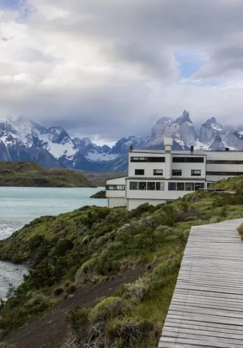
Led by certified guides, Explora offers more than 40 small-group activities tailored to interest and fitness level. Guests hike to famous sites like the Torres base, ride through valleys on Explora’s own horses, and explore the lodge’s private 15,000-acre conservation reserve.
Popular Options:
- Guided hikes and glacier visits
- Horseback riding with local breeds
- Exclusive access to Explora’s reserve
- Wildlife viewing and cultural explorations
Explora Torres del Paine blends luxury and adventure for an unforgettable Patagonia experience.
Hiking Excursion Example
BOSQUE
Easy
Lago Grey
Leave by van for the Lake Grey sector. From there, begin the walk by crossing the Pingo River through a forest until reaching the lakeshore. Walk along the beach with views of the Grey Glacier and the ice floes that break off of it.
Type: Half-day
Duration: 4h
Distance: 5,3 km / 3,3 mi
Max. Altitude: 82 m / 269 ft
Elevation gain: 126 m / 413 ft
Elevation loss: -126 m / -413 ft
Moderate
Pingo Chorrillo
Travel by van to Grey Lake. From there, walk along a path along the Pingo River through a forest of native trees. During this exploration, enjoy different views of the Paine massif and bird watching. The return is by the same path.
Type: Half-day
Duration: 5h
Distance: 9 km / 5,6 mi
Max. Altitude: 105 m / 344 ft
Elevation gain: 235 m / 771 ft
Elevation loss: -235 m / -771 ft
Expert
Ferrier
Travel by van to Grey Lake where travelers begin a demanding ascent during which travelers get views of the Lake and the huge ice mass of the South Ice Fields. Cross a forest and continue to the top with panoramic views of the Grey and Pehoe lakes. Descend and return by van.
Type: Half-day
Duration: 4h 30m
Distance: Half-day
Max. Altitude: 642 m / 2.106 ft
Elevation gain: 612 m / 2008 ft
Elevation loss: -612 m / -2008 ft
CONSERVATION RESERVE
Easy
Rio Zamora
Walk through the western sector of the Torres del Paine Conservation Reserve, with views of the Zamora Canyon and river, passing through Magellanic forests and rock monoliths. Throughout the journey, one can admire views of the impressive "V"-shaped canyon of the Zamora River and the Paine mountain range, including the Obelisco Hill. The local flora is rich in coiron, matabarrosa, lenga, mataguanacos, and nirre, while the fauna includes guanacos, pumas, chingues, caranchos, condors, bandurria, chuncho, among others.
Type: Half-day
Duration: 2h
Distance: 4,9 km / 3,1 mi
Max. Altitude: 489 m / 1604 ft
Elevation gain: 157 m / 515 ft
Elevation loss: -126 m / -413 ft
Easy
Los Bosques
Walk through the Laguna Jara sector and see different landscapes, such as La Vega (wetland), steppes, forests, mountains, and valleys. Tour this territory to observe different flora and fauna like coirón, matabarrosa, ñirres, guanacos, pumas, chingues and flamingos, among others.
Type: Half-day
Duration: 5h 15m
Distance: 5,6 km / 3,5 mi
Max. Altitude: 489 m / 1604 ft
Elevation gain: 110 m / 361 ft
Elevation loss: -141 m / -463 ft
Moderate
La Pampa
Hike across the steppe of the reserve, surrounded by mountains, steppe, and valleys. Along the way, you will be able to enjoy views of the Paine range, Cerro Obelisco, Laguna Jara, and Sierra Baguales. The local flora is rich in coirón, matabarrosa and ñirre, while the fauna includes guanacos, pumas, chingues, caranchyos, condors and flamingoes, among others.
Type: Half-day
Duration: 3h
Distance: 6,8 km / 4,2 mi
ENCUENTRO
Easy
Mirador Toro
Travel by van to the Weber Bridge, from which travelers walk to Toro Lake. On the way, travelers can observe evidence of the ice that once covered the park. Ascend to an overlook with panoramic views. On the descent, pass by a lagoon. Return by van.
Type: Half-day
Duration: 2h 30m
Distance: 2,1 km / 1,3 mi
Max. Altitude:
83 m272 ft
Elevation gain:
98 m322 ft
Elevation loss:
-98 m-322 ft
Easy
Nordenskjold
Travel by van to Salto Grande and begin the trek with views of the Paine Grande and its hanging glaciers. Then, reach the turquoise waters of Lake Nordenskjöld, at the foot of the massif where the sound of breaking ice can occasionally be heard. Return to the lodge by van.
Type: Half-day
Duration: 2h
Distance: 6,3 km / 3,9 mi
Max. Altitude:
116 m381 ft
Elevation gain:
133 m436 ft
Elevation loss:
-139 m-456 ft
Moderate
Mirador Condor
Leave the hotel and walk along the shore of Pehoe Lake. In the distance, see a hill on the summit of which is the Condor lookout, the destination. On the way, pass through Lenga and ñirre forests. When travelers get to the top, have a 360° view of the park. Descend down a rocky slope to the van.
Type: Half-day
Duration: 2 h 30 m
Distance: 3,6 km / 2,2 mi
Max. Altitude: 239 m / 784 ft
Elevation gain: 253 m / 830 ft
Elevation loss: -232 m / -761 ft
Moderate
Alto Del Toro
Travel by van to a steep path facing the Paine River. Begin the trek towards the mountain range passing through an old forest. Continue ascending to an overlook with unparalleled views of the Paine massif and the lakes that surround it. Then, begin the descent towards the van.
Type: Full-day
Duration: 5h
Distance: 13,7 km / 8,5 mi
Max. Altitude: 411 m / 1.348 ft
Elevation gain: 693 m / 2274 ft
Elevation loss: -693 m / -2274 ft
Advanced
Cornisas
Walk towards the Paine River until you reach the cliffs that give name to this exploration. As travelers gain altitude, have panoramic views from different perspectives. See the Paine River, Pehoe Lake and at the top, you can contemplate the Paine mountain range and the surrounding valleys.
Type: Half-day
Duration: 2h 55m
Distance: 6 km / 3.7 mi
Max. Altitude: 373 m / 1224 ft
Elevation gain: 28 m / 92 ft
Elevation loss: -427 m / -1401 ft
ESTEPA
Easy
Sarmiento
Walk along a trail with low vegetation and views of the Paine Horns and Almirante Nieto. Go down to the beach on the shores of Lake Sarmiento, where travelers will have the chance to walk among incredible calcium carbonate rock formations.
Type: Half-day
Duration: 3h 30m
Distance: 4 km / 2,5 mi
Max. Altitude: 125 m / 410 ft
Elevation gain: 100 m /328 ft
Elevation loss: -100 m / -328 ft
Moderate
Aonikenk
Travel by van to the eastern sector of the park, where travelers hike, exploring the wildlife. During the walk, visit a cave with paintings that are over 4,000 years old. Observe the geese, ducks, and swans in the lagoons that are on the way. The terrain has various ascents and descents without steep slopes. Return by van.
Type: Half-day
Duration: 3h
Distance: 7,6 km / 4,7 mi
Max. Altitude: 329 m / 1079 ft
Elevation gain: 303 m / 994 ft
Elevation loss: -237 m / -778 ft
GLACIAR
Moderate
Valle Del Frances
Cross the Pehoé Lake by catamaran to the Paine Grande refuge where travelers start the trek. Enter the Francés Valley through a forest, cross the suspension bridge over the Francés River, and continue to the Italian Camp. From there, see the glacier and the granite peaks that frame the area. Return by the same trail.
Type: Full-day
Duration: 6h
Distance: 18,4 km / 11,4 mi
Max. Altitude: 275 m / 902 ft
Elevation gain: 632 m / 2073 ft
Elevation loss: -632 m / -2073 ft
Moderate
Glaciar Grey
Cross the Pehoé Lake by catamaran to the Paine Grande refuge to cross one of the stretches of the W. Around the midpoint of the hike, see the Grey Glacier and the Southern Ice Fields. Continue walking to the beach of Grey Lake where travelers board a boat that brings them to the glacier and then leaves them on the other side of the lake. Walk along the beach and through a forest to the van.
Type: Full-day
Duration: 7h 15m
Distance: 12,4 km / 7.7 mi
Max. Altitude: 273 m / 896 ft
Elevation gain: 538 m / 1765 ft
Elevation loss: -516 m / -1693 ft
Expert
Campamento Britanico
This exploration takes us along one section of the W. circuit. Cross Lake Pehoé by catamaran to the Paine Grande shelter, where travelers will begin a hike to Valle del Francés. Cross lenga forests to the Mirador Británico, a place with 360° views of the natural amphitheater formed by the Horns and imposing rock formations such as the Shark’s Fin and the Fortress.
Type: Full-day
Duration: 8h
Distance: 29,6 km / 18,4 mi
Max. Altitude: 712 m / 2.336 ft
Elevation gain: 1192 m / 3911 ft
Elevation loss: -1184 m / -3884 ft
Expert
Guardas
Cross Pehoé Lake on a catamaran to the Paine Grande Refuge where travelers begin their trek to the Grey Refuge. From there, walk towards the viewpoint at Guardas camp with panoramic views of the glacier. Return to the refuge. There, board a boat that will take us to the glacier and then leave us on the other side of Grey Lake. Walk back to the van.
Type: Full-day
Duration: 6h
Distance: 18,5 km / 11,5 mi
Max. Altitude: 306 m / 1.004 ft
Elevation gain: 939 m / 3081 ft
Elevation loss: -920 m / -3018 ft
OTHER SAMPLE HIKING EXCURSIONS
Easy
Mirador Grey
Cross the Pehoé Lake in the Explora catamaran towards the northwest bank. From there travelers will ascend to observe the Grey Glacier and the extraordinary extension of the Southern Ice Fields. Then, return along the trail with views of icebergs. Return by catamaran to Explora.
Type: Full-day
Duration: 5 h 30 m
Distance: 12 km / 7,5 mi
Max. Altitude: 276 m / 906 ft
Elevation gain: 488 m / 1601 ft
Elevation loss:-488 m / -1601 ft
Easy
Laguna Azul
The walk begins at the park ranger’s house, from which travelers will walk along the lagoon shore. See a wetland with diverse birds and the Torres del Paine along the way. Reach a viewpoint at the end and then return to the lodge by van.
Type: Half-day
Duration: 45 m
Distance: 1,1 km / 0,7 mi
Max. Altitude: 234 m / 768 ft
Elevation gain: 22 m / 72 ft
Elevation loss: -16 m / -52 ft
Easy
Mirador Masle
Start by hiking around the Laguna Azul where guanacos and different species of birds commonly meander. Then ascend by a path through which travelers arrive at an overlook with views of the Paine massif. Descending, a van waits for us to return to the lodge.
Type: Half-day
Duration: 1h
Distance: 3,5 km / 2,2 mi
Max. Altitude:
375 m1.230 ft
Elevation gain:
164 m538 ft
Elevation loss:
-164 m-538 ft
Easy
Laguna Larga
Skirt the Larga Lagoon, walking among stromatolite rock formations, whose singular appearance contrasts with the colors of the lagoon and the overall landscape. Continue walking with views of the Paine Horns to a viewpoint overlooking Nordenskjold Lake. Return to the hotel by van.
Type: Half-day
Duration: 1h 30m
Distance: 4,8 km / 3 mi
Max. Altitude: 291 m / 955 ft
Elevation gain: 55 m / 182 ft
Elevation loss: -212 m / -696 ft
Easy
Mirador Pehoe
Leave the lodge on foot along the shore of Lake Pehoe, observing the lenga and nierre trees that make up the local flora. Walk up to a viewpoint, from where travelers will be able to see the expanse of the lake and the Paine range. This walk is a great introduction to the park, as it will allow us to understand where travelers are and the place around us.
Type: Half-day
Duration: 2h
Distance: 3,9 km / 2,4 mi
Max. Altitude: 181 m / 594 ft
Elevation gain: 187 m / 614 ft
Elevation loss: -185 m / -607 ft
Easy
Ribera Serrano
Travel by van to the Serrano entrance, where travelers start their walk. Hike through the Pampa of the same name, guided by the channel and some birds of the Serrano River. Appreciate the contrast of the green meadows and the granite of the Paine massif. Return to the hotel by van.
Type: Half-day
Duration: 1h
Distance: 3 km / 1,9 mi
Max. Altitude: 28 m / 92 ft
Elevation gain: 15 m / 49 ft
Elevation loss: -18 m -59 ft
Moderate
Mirador del Obelisco
Walk through the Cerro Obelisco sector, crossing lenga forests before reaching a viewpoint where mountain ranges and valleys can be observed, in addition to the old 2 de Enero estate in what is currently the Torres del Paine Conservation Reserve.
Type: Full-day
Duration: 5h
Distance: 7,3 km / 4,5 mi
Max. Altitude: 928 m / 3045 ft
Elevation gain: 656 m / 2152 ft
Elevation loss: -686 m / -2251 ft
Moderate
La Estrella
Walk through a lenga forest and observe different types of vegetation and panoramic views. The sound of woodpeckers will accompany us along the way.
Type: Full-day
Duration: 6h
Distance: 6 km / 3,7 mi
Max. Altitude: 1000 m / 3281 ft
Elevation gain: 513 m / 1683 ft
Elevation loss: -536 m / -1759 ft
Moderate
Origines
The hike starts at the lodge through a well-marked upward track, surrounded by low shrubs and ample views. Orchids follow along during the summertime. Get to see some hidden lagoons in the Torres del Paine National Park, condor nesting sites, and some forests. Get a front view of the Paine massif until travelers get to the Sarmiento Chico Lake to examine rock formations of a protracted geological history. Return to the lodge by van.
Type: Full-day
Duration: 6h
Distance: 13,8 km / 8,6 mi
Max. Altitude: 347 m / 1.138 ft
Elevation gain: 515 m / 1138 ft
Elevation loss: -478 m / -1568 ft
Moderate
Graciar Grey
Cross the Pehoé Lake by catamaran to the Paine Grande refuge to cross one of the stretches of the W. Around the midpoint of the hike, see the Grey Glacier and the Southern Ice Fields. Continue walking to the beach of Grey Lake where travelers board a boat that brings us to the glacier and then leaves us on the other side of the lake. Walk along the beach and through a forest to the van.
Type: Full-day
Duration:
5 h 30 m
Distance:
12,4 km / 7,7 mi
Max. Altitude: 538 m / 1765 ft
Elevation gain: 538 m / 1765 ft
Elevation loss: -516 m / -1693 ft
Moderate
Juncales
Travel by van to an area rich in wildlife and birds. Begin the walk bordering a lagoon with reed islets, where a natural habitat for different types of birds has been formed. Continue walking with views of Toro Lake and the hills of Castillo and Tenerife. Recommend this exploration to travelers interested in bird watching.
Type: Full-day
Duration: 6 h
Distance: 10 km / 6,2 mi
Max. Altitude: 85 m / 279 ft
Elevation gain: 241 m / 791 ft
Elevation loss: -239 m-784 ft
Moderate
La Loma
From a steppe area, walk to a small hill overlooking the Torres del Paine. Then cross native forests, observing the rich wildlife of the park. At the end of the excursion, make a descent through open terrain, allowing us to feel the Patagonian wind. Return to the lodge by van.
Type: Half-day
Duration: 2h
Distance: 3,7 km / 2,3 mi
Max. Altitude: 430 m / 1.411 ft
Elevation gain: 58 m / 190 ft
Elevation loss: -234 m / -768 ft
Advanced
Valle Del Rio Pingo
Travel by van to the Grey Lake refuge where travelers start walking along the Pingo River. Cross the river to reach the forests through which the Paine Grande can be seen. Return on the same road to the refuge to get on the van and return to Explora.
Type: Full-day
Duration: 8h
Distance: 21,6 km / 13,4 mi
Max. Altitude: 313 m / 1.027 ft
Elevation gain: 745 m / 2444 ft
Elevation loss: -745 m / -2444 ft
Advanced
Cuernos
Leave by van for the Cerro Paine estate, where travelers begin their walk along Lake Nordenskjöld until reaching the trail up the Bader Valley. Have amazing views of the Horns, the lakes Sarmiento and Nordenskjöld, and the Almirante Nieto glacier.
Type: Full-day
Duration: 7h
Distance: 18,8 km / 11,7 mi
Max. Altitude: 269 m / 883 ft
Elevation gain: 664 m / 2178 ft
Elevation loss: -664 m / -2178 ft
Advanced
Plateau
Travel on your catamaran to the Frances Valley where travelers start the trek to the plateau. Arrive at the Italian Camp and then to an overlook from where travelers have privileged views of the towers and the Francés Glacier. This hike follows a rocky path through the moraine of the glacier.
Type: Full-day
Duration: 7h
Distance: 21 km / 13 mi
Max. Altitude: 485 m / 1.591 ft
Elevation gain: 906 m / 2972 ft
Elevation loss: 906 m / -2972 ft
Advanced
Mirador Sierra Del Toro
Travel by van to the mouth of the Paine River, where travelers begin a steep and rocky ascent of the Sierra, a place off the beaten track. The vegetation is low, allowing incredible views of Toro Lake, Paine River, the Pampa Serrano, and the mountains of the area. Return by van.
Type: Half-day
Duration: 3h
Distance: 4,8 km / 3 mi
Max. Altitude: 432 m / 1.417 ft
Elevation gain: 454 m / 1490 ft
Elevation loss:-454 m /-1490 ft