Guatemala is a country of stunning geographical contrasts, ranging from towering volcanoes and highland peaks to dense lowland rainforests and tropical coasts. Its geography has shaped its history, culture, and biodiversity, making it a top destination for adventure, wildlife, and cultural travelers.
Guatemala’s Geography in Brief
Location: Central America; bordered by Mexico, Belize, Honduras, El Salvador, Pacific Ocean, and Caribbean Sea.
Size: 108,889 km² (42,042 sq mi), the third largest in Central America.
Regions:
Western Highlands: Rugged mountains, volcanic peaks, fertile valleys.
Pacific Coastal Plains: Narrow, fertile plains with sugarcane, bananas, and coffee plantations.
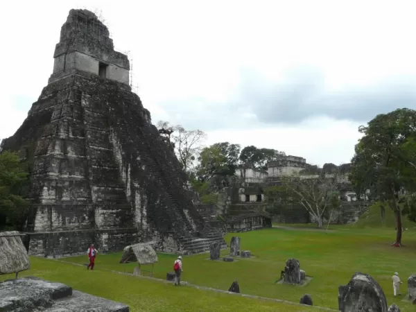
Northern Lowlands (Petén): Dense rainforests, limestone plateaus, and Mayan ruins.
Guatemala’s mountain chains (Sierra Madre in the south, Cuchumatanes and Chamá in the north) divide the country and create dramatic climate and biodiversity zones. Its highest peak, Tajumulco Volcano (4,220 m / 13,845 ft), towers over the highlands. The Motagua Fault and Middle America Trench explain the frequent earthquakes and volcanic activity in the country. Chichicastenango (Maya Trails)
Lakes, Rivers, and Volcanoes
Lakes:
Lake Atitlán: A scenic volcanic lake surrounded by villages, volcanoes, and hiking trails.
Lake Izabal: Guatemala’s largest lake, feeding the Caribbean through the Rio Dulce.
Rivers: Motagua and numerous smaller rivers drain the highlands into the Caribbean and Pacific.
Volcanoes: Active and dormant volcanoes (Pacaya, Fuego, Acatenango) shape fertile soils and adventurous treks.
Ecosystems of Guatemala
Guatemala is a biodiversity hotspot, ranking #5 globally. Its 14 eco-regions include tropical rainforests, cloud forests, mangroves, wetlands, pine forests, and dry forests.
Ecosystem
Location
Key Features
Wildlife Highlights
Tropical Rainforests
Petén, Northern Lowlands
High rainfall, dense canopy
Jaguars, howler monkeys, scarlet macaws
Cloud Forests
Highlands
Cooler, misty, nutrient-rich soil
Resplendent quetzal, orchids, amphibians
Mangroves & Wetlands
Pacific & Caribbean coasts
Coastal protection, fish nurseries
Crocodiles, shrimp, migratory birds
Marine Ecosystems
Caribbean coast, Gulf of Honduras
Coral reefs, brackish estuaries
Turtles, lobsters, tropical fish
Coati in Tikal National Monument (Julie Bleau)
Wildlife of Guatemala
Guatemala’s location and variety of habitats make it a paradise for wildlife enthusiasts.
Guatemala’s geography, ecosystems, and wildlife offer a rich mix for travelers seeking nature, adventure, and culture. From highland volcanoes to tropical lowlands, there is a world of landscapes and species to explore, all within a single, compact country.
Our team is waiting and ready to talk with you about your next adventure.
So go ahead and book an appointment with one of our specialized trip planners.