Indonesia Geography: Exploring the World’s Largest Archipelago
The country of
Indonesia is the largest island nation when the total area of its land mass is summed up. With over 17,500 islands, the country spans across several seas and between the Indian and Pacific Oceans, starting in the West with the island of Sumatra, all the way to Irian Jaya to the East. A large section of Borneo Island is governed by Indonesia, and the larger islands of Java, Bali, and Sulawesi contribute to its area.
Given the breadth of its area, the type of landscapes it comprises is also vast. Indonesia’s ecosystems range from tropical jungle to rice paddies and terraced hillsides, to savannah grasslands and volcanic mountain ranges, and black sand beaches. The environment creates habitat for an abundance of flora and fauna, including the rare Sumatran tiger and elephant, the Javan rhino, and the Komodo Dragon. Indonesia is most notably popular for its pristine beaches and well-preserved marine life. The coral species here are vast, and the visibility of many islands and their shallow coral systems is often clear year-round.
Where Is Indonesia Located?
Indonesia is located in Southeast Asia, positioned between the Indian Ocean and the Pacific Ocean, which strongly shapes its climate, marine life, and trade routes. As a vast island nation, Indonesia sits between Asia and Australia and is made up of more than 17,000 islands spread across the region. It shares land borders with Malaysia, Papua New Guinea, and Timor-Leste. In terms of coordinates, Indonesia stretches from about 6° north to 11° south latitude, placing it directly along the equator. This equatorial location explains the country’s warm temperatures, frequent rainfall, and dense rainforests, key features that define Indonesia's geography and the overall geography of Indonesia.
The Islands and Regions of Indonesia
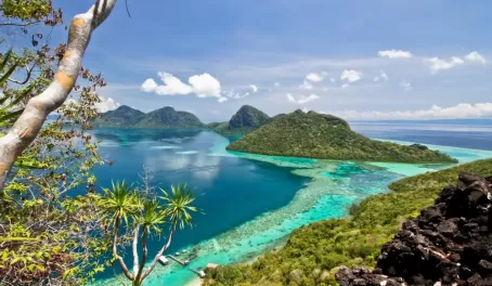
Indonesia is made up of more than 17,000 islands, which is why it’s known as the Indonesian archipelago. These Indonesian islands stretch across Southeast Asia and Oceania and are grouped around five main islands: Sumatra, Java, Kalimantan, Sulawesi, and Papua. While the country covers a huge land area, people are not evenly spread out. Java takes up only a small portion of Indonesia’s total land but is home to more than half of the population. Other well-known subregions, such as Bali, Lombok, and the Maluku Islands, add to the country’s geographic variety and show just how wide-ranging island life is across the archipelago.
Major Islands and Their Features
Each of Indonesia’s main islands has its own defining traits. Sumatra and Kalimantan are known for their large forests and natural resources. Sulawesi stands out because of its unusual shape and mix of landscapes, from mountains to long coastlines. Papua is the largest island by land area and remains one of the least developed, with rugged terrain and remote communities. Java, on the other hand, is the country’s political and economic center, packed with major cities, industries, and transportation networks.
Lesser-Known Islands Worth Noting
Smaller island groups also play an important role in Indonesia’s geography. Bali and Lombok sit east of Java and are shaped by volcanoes, beaches, and farming communities. Further east, the Maluku Islands are scattered across the sea and have long depended on fishing and maritime trade. These lesser-known areas highlight how the Indonesian archipelago is not just large, but also varied, with islands that differ greatly in size, population, and way of life.
Volcanoes and Mountains of Indonesia
Indonesia sits along the Pacific Ring of Fire, which is why Indonesia's volcanoes are such a big part of the country’s story and its geography. With more than 130 active volcanoes, dramatic mountains rise across many islands, shaping coastlines, valleys, and everyday life. Famous volcanoes like Krakatoa, Mount Bromo, and Mount Merapi are powerful reminders that this land is always changing. While eruptions can be dangerous, they also leave behind incredibly fertile volcanic soil, helping farmers grow rice, coffee, and other crops. This mix of towering mountains and productive farmland is a key reason Indonesia’s landscape looks the way it does today.
Rivers, Lakes, and Natural Resources
Indonesia’s rivers and lakes play a big role in everyday life across the islands. Major lakes like Lake Toba in Sumatra, Lake Poso, and Lake Matano provide fresh water, support fishing, and help nearby communities make a living. Rivers are just as important, especially in areas where roads are limited. They are used to move people and goods, water crops, and support farming and fishing. Together, these waterways help sustain daily life, local economies, and food supplies across the country.
Climate and Weather Patterns
Indonesia has a tropical climate, which means it stays warm and humid all year. Because of this, the weather here is shaped mostly by rainfall rather than temperature changes. The country experiences two main seasons: the dry season from May to October and the rainy season from November to April. During the dry months, many areas see sunnier days and lower humidity, especially in southern regions. The rainy season brings heavier downpours, higher moisture levels, and occasional flooding, particularly in western islands like Sumatra and parts of Java. Rainfall is not the same everywhere, mountain areas and western islands usually get more rain than eastern Indonesia. These patterns are a key part of the geography of Indonesia, influencing farming, travel, and daily life.
Large-scale climate events also play a role. El Niño often causes drier-than-normal conditions, leading to droughts and water shortages in some regions. On the other hand, La Niña brings stronger rainfall, which can increase the risk of floods and landslides. These shifts make Indonesia’s weather less predictable from year to year.
How Indonesia’s Equatorial Location Affects Its Climate
Indonesia sits right along the equator, and this location explains much of its climate. Sunlight is strong and consistent throughout the year, so temperatures stay fairly stable with little seasonal change. Warm air rises quickly near the equator, helping form clouds and frequent rain. This is why humidity is high and sudden rain showers are common, even outside the main rainy season.
Biodiversity and Ecosystems
Indonesia’s biodiversity is shaped by its mix of tropical rainforests, coral reefs, and mangrove ecosystems. Its rainforests are home to rare wildlife like the Sumatran tiger and orangutan, while its seas support some of the most diverse coral reefs on the planet. Along the coasts, mangroves protect shorelines and provide nurseries for fish and marine life. This natural variety also includes iconic places like Komodo National Park, where the Komodo dragon lives, and Lorentz National Park, one of the largest protected areas in Southeast Asia. Together, these ecosystems show why Indonesia is considered one of the most biologically important countries in the world.
Human Geography: Population and Land Use
Human geography in Indonesia is closely tied to its physical landscape. People tend to settle where the land is most productive, which is why Java is so densely populated. Its volcanic soil is extremely fertile, making it ideal for farming and supporting large communities for centuries. Major cities like Jakarta, Surabaya, and Medan have grown quickly as people move to urban areas for jobs, education, and better access to services. Outside the cities, rural areas still depend heavily on agriculture, while coastal communities focus on fishing and trade. However, population growth and land demand have led to deforestation in some regions, especially as forests are cleared for farms, housing, and plantations. This shows how closely people’s daily lives and land use are shaped by Indonesia’s geography, and how human activity, in turn, affects the environment.
Challenges in Indonesia’s Geography
One of the biggest challenges tied to the geography of Indonesia is its constant exposure to natural disasters. Sitting along the Pacific Ring of Fire means earthquakes, volcanic eruptions, and even tsunamis are part of life in many areas. On top of that, environmental problems like deforestation, soil erosion, and frequent flooding put pressure on both rural communities and growing cities. These issues affect food supply, housing, and long-term safety for millions of people. To address this, Indonesia continues to work on better land management, forest protection, and climate adaptation plans to reduce risks and protect both people and nature.
Fun Geography Facts About Indonesia
When it comes to geography, Indonesia has some seriously cool facts. For one, the country stretches across three different time zones, which shows just how wide it really is. It’s also home to Lake Toba, the largest volcanic lake in the world, formed after a massive eruption thousands of years ago. And if that’s not impressive enough, the rainforest on Borneo is older than the Amazon, making it one of the oldest tropical rainforests on Earth. These facts alone give a clear picture of how huge, diverse, and geologically fascinating Indonesia truly is.
Plan Your Trip to Indonesia
Planning a trip to Indonesia starts with understanding its geography. This country is made up of thousands of islands, and each region feels different, from beach towns to volcano-filled highlands, so timing and location matter.
When to Visit
For most parts of Indonesia, the best time to go is during the dry season, from May to October. These months are ideal for island hopping, hiking, and beach trips, with less rain and more reliable weather. That said, some areas have their own patterns. Bali and Java can still be good to visit outside these months, though short rain showers are more common.
Top Natural Destinations
Indonesia’s geography gives travelers a wide mix of landscapes to choose from. Bali and Lombok are known for beaches, coastal views, and underwater life, with mountains rising not far from the shore. Komodo Island is famous as the natural habitat of the Komodo dragon. In Sumatra, you’ll find Lake Toba, surrounded by cooler highlands and dense rainforests. Over on Java, Mount Bromo offers dramatic volcanic scenery, while cities like Yogyakarta add depth to any nature-focused trip.
By matching the season with the region you want to visit, Indonesia’s geography makes it easy to plan a trip that fits your travel style, whether that’s beaches, mountains, wildlife, or a mix of everything.
Ready to start planning your Indonesia adventure? Let us help you turn your travel ideas into a well-planned trip.
Contact one of our trip planners to get started.