During the summer of 2011, we began planning for our trip to Peru. The Adventure Life travel agency of Missoula, Montana, specializing in Central and South American travels, was selected as we endorsed their philosophy of utilizing local lodging, transportation and guides, maintaining small groups, and being ecologically responsible. Our tour guide for the first 10 days from Lima to Puno was Carlos Lazo, while our guide for the last 5 days in the Cusco region was Teddy Romero. A mother and her 17-year-old son (Sarah and Christopher) were the 2 other members of our group. Peru is in the Eastern Time Zone but does not observe daylight saving time. Sunrise occurred at approximately 6:20 am and sunset near 5:50 pm. Peru is located in a temperate zone and has two climates – wet (Dec – Mar) and dry. Days were sunny with temperatures between 60-70 degrees. Nights at higher elevations dropped between 30 and 40 degrees.
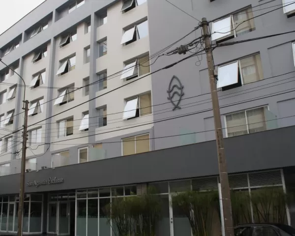
San Agustin Hotel in Lima (Dick Morasch).
The long-awaited Panoramic Peru trip started with our noon departure flight on United Airlines from Reagan International Airport in Washington DC with a connecting flight in Houston, Texas. Careful packing allowed for carry-on luggage, thus ensuring bags arriving with us. Flights were uneventful and we arrived in Lima at 11 pm. A local driver from Adventure Life accomplished the transfer from airport to hotel. Although nighttime, we were able to observe the beauty of the region as we left the city of Lima and rode along a stretch of the Pacific Ocean toward our hotel. The coastal area featured wide beaches, recreation facilities and bike paths, with the city perched high above on sheer cliffs. Upon arrival at the San Agustin Hotel, which was located in Miraflores, a suburb of Lima, the first of many pisco sours was enjoyed followed by a shower and welcome bed.
We stayed in 9 different hotels during our travels and all were comfortable. A buffet style breakfast consisting of coffee, tea, juices, eggs, pancakes, cereal, yogurt, ham, cheese, a variety of bread and rolls, and fresh fruit was served at all hotels. Lunches were usually eaten mid-afternoon and often times were elaborate buffets of local food, including beef, alpaca, guinea pig, chicken, potatoes, quinoa, soups, breads, fresh fruit, and several types of flan or mousse. A relaxing dinner and drinks usually occurred near 8 pm in a restaurant of our choice. The commercial bus line Cruz del Sur provided transportation for longer trips, while shorter trips were by a comfortable 11-passenger Mercedes Benz luxury van.
A Passport and Immigrant Card were required at every hotel check-in, as well as at every transportation center.
DAY 2 - THURSDAY
May 31, 2012
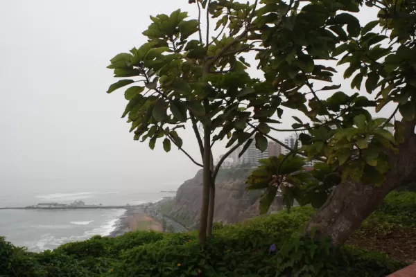
Overlooking the ocean in Lima (Dick Morasch).
Following a 7:30 am breakfast, Dick and I made a quick trip to the ATM and then walked approximately seven blocks to the coast. The streets were very busy with cars and pedestrians. Although we did not observe stop signs or lane markers, it was amazing to see the autos merging and crossing intersections without incident. Car horns warned of approaching vehicles and it was apparent that autos had the right of way. Numerous luxury hotels, shops, and businesses lined the cliffs overlooking the ocean. Cliffs were covered with flowers and shrubs and the drop-off was dramatic. Skies were overcast with a temperature of 70 degrees.
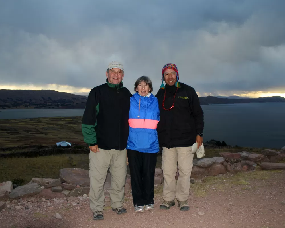
The official tour started at 12:30 pm with the arrival of Carlos Lazo, our guide from Adventure Life who was to be with us for the next 10 days. Carlos, a resident of Arequipa, proved to be well organized and a fountain of knowledge regarding past and present history of Peru, culture, birds, fauna, flora and public policy. At 1:30 pm we boarded the Cruz Del Sur bus for the 4-hour drive down the Pan American Highway to Paracas. The commercial bus had 2-levels with the lower level containing 12 large reclining seats. The provision of food and beverages, pillows, blankets and television ensured a pleasant trip. South of Lima, the Pacific Ocean provided a sharp contrast to the squatter villages populating the arid hilly terrain to the east. Further south, the sky turned blue as we entered the agricultural area. Irrigated fields producing cotton, corn, potatoes, onions, avocados, and asparagus as well as a variety of grains were visible. Fishing and agriculture are the most important sources of livelihood although tourism is now growing. The area is also susceptible to earthquakes and tsunamis, the latest being a 7.9 quake in 2007.
We arrived at the La Hacienda Hotel at 6 pm. Unfortunately, we missed sunset over the bay with sunset occurring at 5:50 pm. Located on the Bay of Paracas, La Hacienda was a modern, beautiful resort featuring the elements of the Peruvian desert – wood from the huarango tree, stone, and clay. Flowering bougainvilleas surrounded the pool that appeared to flow into the bay. Following a late dinner featuring fresh seafood with Carlos, Sarah and Christopher, we walked around the grounds prior to returning to our room at 11 pm.
DAY 3 - FRIDAY
Jun 01, 2012
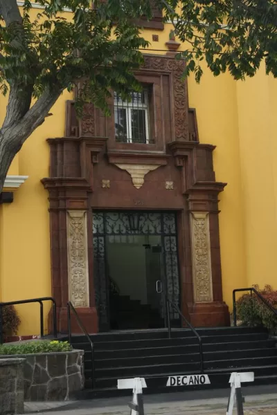
One of Lima's beautiful buildings (Dick Morasch).
ISLAS BALLESTAS TOUR
This small group of rock formations was located in the middle of the Humboldt Current that flows 2,000 miles from Antarctica along the Pacific coastline. The warm shallow waters along the Peruvian coast stimulates the growth of phytoplankton, which in turn stimulates an ecological food chain that culminates in the largest concentration of birds on earth. Guano collectors are the only humans allowed on the Islas with collections occurring once every 10 years.
PARACAS NATIONAL PRESERVE TOUR
The Paracas National Reserve includes the Paracas Bay and Peninsula along with the Islas Ballestas, which are located 10 miles off shore in the Pacific Ocean. Established in 1975 and the primary marine conservation center in Peru, the Reserve is two-thirds ocean. Dirt roads crisscross the hot desert land, reaching small fishing villages, and offering spectacular views of red, black or gray cliffs and beaches, as well as the ocean. The arid climate and layers of sand provided protection to the elaborate embroidered textiles that are now recognized as the finest representatives of pre-Columbian woven art.
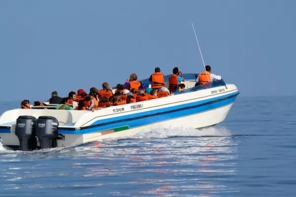
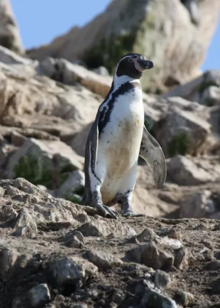
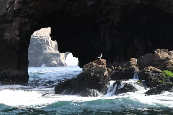
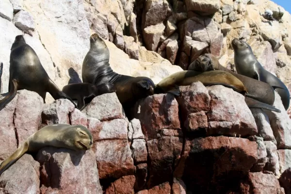
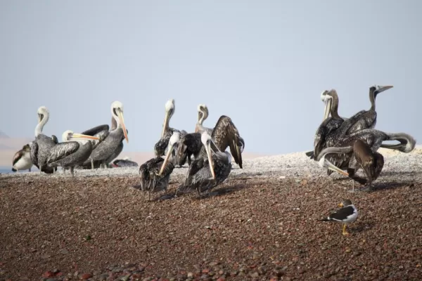
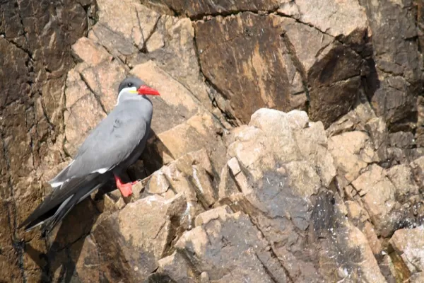
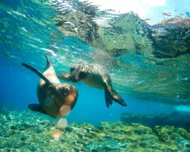
We woke at 6 am in order to be ready for our ride to the harbor and the trip to the Islas Ballestras that was scheduled from 8-10:30 am. A 25-passenger speedboat provided the 10-mile ride to the islands. A cloudless sky provided a beautiful contrast to the varied blue and green shades of the water. The shoreline was hilly and arid but colorful due to the different mineral content in the soil. En route to the Islas, we viewed the Candelabro, a giant candelabra-like drawing etched into a cliff overlooking the bay. Although its history remains unknown, some believe it to be a ritualistic symbol of the Paracas or Nasca cultures, while others believe it served as a protective symbol or navigational guide for sailors and fishermen. Upon reaching the Islas, we viewed Humboldt penguins, the South American sea lion (nursing her pup), red-footed cormorants, the Peruvian booby and hundreds of other Guano producing birds perched upon the rocky cliffs. Several pods of dolphins were also observed.
At 11:30 we began the land tour of the Paracas National Reserve. Our local guide was more than pleased to share his wealth of knowledge of the Paracas culture dating from 7000 B.C until 200 A.D. Traveling over deserted salt covered dirt roads with sand dunes resembling a moonscape, we stopped to view the former Cathedral Rock formation that crumbled during the earthquake of 2007. The different mineral content in the cliffs resulted in a black beach as well as red beach, which were formed by the magnesium oxide in the cliffs. Along the shoreline, local residents were seen harvesting kelp to be used in the production of collagen.
Lunch was served at a picturesque fishing village on the bay. Large pelicans hovered at the doorway awaiting the discards from the cleaning of the fresh fish. Bass ceviche was delicious as was the chichi - a purple corn drink flavored with cinnamon. A quick stop at the local information center/museum completed our tour.
At 3 pm we returned to the La Hacienda to retrieve our luggage prior to the 6 pm bus departure to Nasca. Dick and I enjoyed a well-deserved cerveza following a busy day in the sun. We arrived in Nasca at 9 pm and were driven to the Hotel Majora that was located about 10 minutes from town, down a long bumpy dusty dirt road. A simple but delicious chicken and rice dinner was served at 10 pm. Although our room was small, it was comfortably furnished with antiques and framed fragments of ancient textiles. Doorways were ornately carved and colorful murals were painted on the walls.
DAY 4 - SATURDAY
Jun 02, 2012
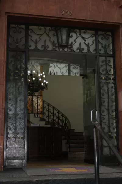
Stunning building entrance (Dick Morasch).
Although we could sleep-in today, Dick and I both rose early to walk around the hotel prior to 10 am scheduled fly over of the Nasca Lines. Again, a delicious breakfast was served with plates and baskets of bread covered by tiny linen napkins. The history of the current Hotel Majora can be traced to 1698 when the 100 hectares property was given to the Saint Augustin Convent. In 1910 it became a private property run by an aristocratic family who Iater remodeled the old convent into a Casa Hacienda and in 1980 into the current Hotel Majora. Hotel furnishings included original paintings from well-known Peruvian artists, old woven tapestries or pre-Columbian textiles, and furniture from the Colonial and Republican era. Gardens lush with poinsettia, bougainvillea, bird of paradise, lantas, begonias, pentas, and orange and lemon trees also featured fountains, pools, statuary, llamas, and peacocks.
NASCA LINES
The town and drawings are names for the Nasca culture that dominated this area along the southern desert coast from 300 B.C. - A.D. 700. The Nasca area is renowned for exquisite stylized pottery as well as the stone aqueducts that allowed agriculture to flourish in the harsh desert. The town was devastated by an earthquake in 1996 and is slowly rebuilding. The Nasca Lines consist of massive mysterious drawings etched into the sands of the pampas or the sides of mountains during pre-Columbian times. The vast tapestry of geoglyphs include trapezoids, triangles, 70 animal and plant figures, and more than 10,000 lines. With some figures reaching nearly 1,000 feet in size, they could only be appreciated from the air.
Although extremely apprehension, I boarded the 6-seat Cessna 172 style plane for a 40-minute flyover of the famous Nasca Lines. Flying at 3200 feet, the flight path allowed us to view thirteen of the famous symbols etched on the plateaus or sides of the mountains (whale, trapezoids/triangles, astronaut, monkey, dog, condor, spider, bird, hummingbird, Alcatraz, parrot, tree, and hands). In order for every passenger to experience optimal visual impact, the pilot would dip the right wing of the aircraft, point out the symbol below, level, circle, and then dip the left wing of the aircraft to repeat the procedure. Thank goodness for Dramamine. The terrain was a wide expanse of craggy, dusty, origami-like folds in the sand, while the irrigated land closer to the town was a lush agricultural area.
CHAUCHILLA CEMETERY
Dating back to the Inca-Chincha period of 1000-1400 A.D. the Chauchilla Cemetery has only been open to the public since 1997. The very dry condition of the desert helped preserve the mummies over the centuries. Fragments of textiles, feathers, and bones scattered about the site were clues to the cemetery's discovery by grave robbers. Only in the past few years were the tombs covered with thatch roofs, thus the skulls appear whitewashed from the blazing sun. The restoration of the cemetery remains severely underfunded.
Following a large lunch featuring Lomo Saltado and pisco sours in the town of Nasca, we started our tour of the Chauchilla Cemetery with a knowledgeable local guide. Following a dirt road approximately 5 miles off the paved highway, we came upon an immense flat and arid landscape surrounded by towering hills doted with small silver mining shacks. In this land of absolute solitude and desolation, we came upon a small building housing the local cemetery guard and his family, as well as a one-room museum. Following our guide down a path we reached the first open tomb. Imagine our surprise to view three mummies wrapped in cotton, clothed and bound with cord, seated in a fetal position facing east, along with a pile of white femurs wrapped in cloth, as well as three skulls. The cemetery contained twelve such tombs, each covered by a wood supported thatch roof and approximately 5x5x5 feet in size. Numerous depressions and mounds in the area indicated the work of grave robbers. Small fragments of bones and pottery remained scattered above ground. Unnerving, to say the least.
Returning to Nasca, we stopped at the home of a local pottery maker followed by another visit to the home of a miner and jewelry maker for a demonstration of Peruvian gold mining in Nasca. We then returned to the Hotel Mayora to relax, collect our luggage prior to 10 pm departure by bus to Arequipa. Although the ride followed the Pan American Highway, it was long, curvy and bumpy and at times uncomfortable. However, the stretch of highway along the coastline was magnificent as a full moon shone over the waves crashing on the coastline of the Pacific Ocean.
DAY 5 - SUNDAY
Jun 03, 2012
A closer view of the entrance (Dick Morasch).
AREQUIPA
Arequipa is located at 7661 feet above sea level and is surrounded by three snow-capped volcanoes all of which hover near 20,000 feet - Chachani, El Misti and Pichu Pichu. Possibly due to global warming and ozone deterioration, in 2009 the peaks were only snow covered during the winter months of June, July and August, instead of the usual twelve months of snow cover. Founded in 1540, Arequipa is the second largest city in Peru. Its historical city center is constructed almost entirely of silla that is a porous white volcanic stone. Arequipa enjoys more than 300 days a year of sunshine and low humidity. Unfortunately, the city has a history of natural disasters. The earthquake of 2001 registering 8.1 on the Richter scale destroyed the major portions of the city, including the towers of the Catedral located in the Plaza del Armas. The day after our visit, an earthquake measuring 5.2 was felt in the city. Pulitzer Prize winner Mario Vargas Llosa was born in Arequipa.
We arrived in Arequipa at 6 am under bright blue skies. After checking in at the Casa Andina Hotel, located within a short walking distance of the historical center, our energetic guide Carlos started our walking tour of the city with our destination being the Plaza de Armas. A large elegant square with massive plantings of hydrangeas, pentas, and salvia under towering palm trees surrounding a central fountain, the plaza is the focus of urban life in Arequipa. On this early Sunday morning, the Plaza was filling with families and vendors as well as soccer fans that intended to watch the 4:30 semi-finals on the large screens being set up in the Plaza. The Plaza is surrounded by the Cathedral, small porticoed shops and restaurants.
CATHEDRAL
The Cathedral is a 17th century neoclassical structure that is rather modest compared to other Cathedrals in South and Central America. The interior is peach and white with carved arches and a massive pipe organ. The Cathedral is now fully restored to its original grandeur after being devastated by earthquakes and natural disasters.
After sampling and purchasing several delicate cream filled cookies at a small pastry shop, we headed to the bustling indoor-outdoor Sunday market. Opening at 4 am, farmers and vendors from surrounding villages displayed their goods while villagers and local residents made their purchases. Typical of most markets, it was divided into sections featuring meat, cheese, fruit, vegetables, medicinal plants, juices, house wares, clothing etc. After enjoying a fresh juice beverage we left the smell-laden market and headed toward the Jesuit church of La Campania. Although we were unable to enter the main chapel due to Mass, we were able to view the small domed Capilla Real, or Royal Chapel. We then walked thru the Jesuit cloister which now house upscale boutiques where I purchased an alpaca/silk scarf.
LA COMPANIA
The 17th century Jesuit Church with its elaborate facade carved of sillar stone took more than a century to be completed. The interior holds a carved-cedar main alter covered in gold leaf and two chapels: the Capilla de San Ignancio with an elaborate painted cupola, and the Capilla Real which features vivid painted murals of a jungle motif around its circular sacristy.
Hungary and fatigued, we now convinced Carlos that we were capable of navigating the city and encouraged him to return home to watch the soccer match with his family. (Our tour schedule indicated that Sunday was a free day without a guide, and we assumed Carlos felt responsible for his non-Spanish speaking tourists.) After brief resistance, Carlos bid us farewell. Dick and I then headed to a small restaurant overlooking the Plaza where we enjoyed a cold drink and delicious lunch.
MUSEO SANTUARIOS ANDINOS
'Juanita' is the ice-packed mummy of the 14-15 year old Inca female sacrificed at the 20,000 foot Ampato Volcano and now displayed at the Museo. It is believed that that the sacrifice was an appeasement to Ampato whose dominion was the water supply and harvest. Juanita was discovered at the summit of the Ampato volcano in 1915 by a team of anthropologists led by Johan Reinhard, the National Geographic explorer-in-residence. Packed in ice and thus not desiccated like most mummies, Juanita was the first frozen female found from the pre-Columbian era in the Andes. Her well-preserved corpse allowed scientists to examine her DNA, skin, hair, blood, internal organs and contents of her stomach. Controversy now clouds the discovery as locals claim a locally famous mountaineer named Carlos Zarate should be credited with the discovery.
First stop after lunch was the Museo Santuarios Andinos located a few blocks from the Plaza to view Juanita, the Inca Ice Maiden. Now nearly 3:30 pm, we then walked the short distance to the Monasterio De Santa Catalina and spent an hour or more walking the streets and exploring the cells of the beautiful convent. Although exhausted we climbed a set a steep stairs to the rooftop for a panoramic view of the city.
MONASTERIO DE SANTA CATALINA
Founded in 1579 under the Dominican order, the convent is a small labyrinthine village with narrow cobblestone streets, plant-lined passages, plazas, fountains, chapels and small cells where more than 200 sequestered nuns once lived. Although the nuns, all from wealthy Spanish families, entered the convent under the vows of poverty, they each paid a dowry to live the monastic life amid art collections, a well-equipped kitchen and servants. Behind tall and thick sillar fortifications, walls are painted sunburned orange, cobalt blue, and brick red. The convent contains three cloisters, six streets, 80 housing units, an art gallery and cemetery. Its mudejar (Moorish-Christian) architecture and Spanish named streets have the feel of a small village in southern Spain. In 1972 local authorities forced the sisters to install modern infrastructures, a requirement that led to the opening of the convent for tourism. Today only 19 cloistered nuns between the ages of 20 and 90 remain.
Returning to the hotel near 5:30 we showered and rested for a short time before heading out to dinner. We selected the Zig Zag restaurant located a short walking distance from our hotel. The house specialty was stone-grilled meats served on a sizzling stone with a trio of sauces. We both ordered the meat trio entree - alpaca, llama, and beef, served with fingerling potatoes, followed by coffee and dessert. Of course, pisco sours and cervaza contributed to a relaxing and enjoyable evening.
DAY 6 - MONDAY
Jun 04, 2012
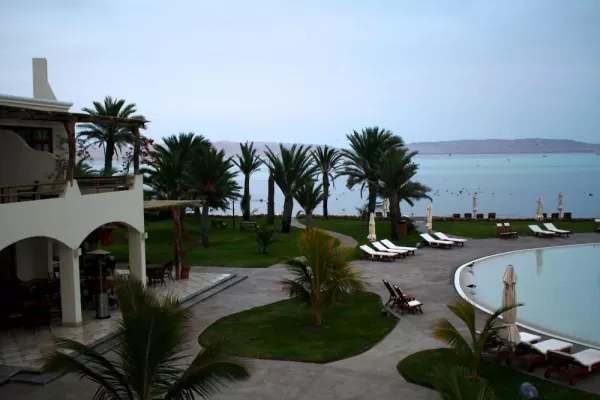
View from our room in La Hacienda Hotel (Dick Morasch).
The plan for today was to drive to the Colca Canyon, 103 miles from Arequipa. The departure scheduled for 8 am was an unusually late start for us. Although the typical driving time was 3-4 hours, we enjoyed numerous stops for photo opportunities and did not arrive at the Colca Lodge until 3:30 pm. Because the drive took us over the 16,100 foot Patapampa Pass, aka Mirador de los Andes, we prepared for the high altitude by stopping at a small convenience store on the outskirts of Arequipa to purchase coca leaves, coca wafers, and coca candy. Use of coca leaves is a used to combat the effects of attitude sickness. The leaves grow in the rainforest, as well in the areas of Cusco and Lake Titicaca. Containing caffeine, it is said the leaves will provide extra energy, control body temperature, reduce headaches and stomach upset. People consume the leaves by drinking in tea, chewing, or consuming in food products.
Passing through the Reserva Nacional Salinas y Aguada Blanca populated only by large herds of grazing domesticated alpacas and llamas, we stopped for photos and learned the differences between the animals. Llamas are tall with a long neck, a large hairless face, and large ears. Their tail points upward when they walk. Llamas have a less fine fiber and are more suited as beasts of burden. Alpacas are about a foot shorter, have smaller heads and ears, and walk with tails pointed downward. Alpacas produce about 10 pounds of extremely fine soft lightweight fiber per year.
Further down the highway at an elevation of 12,000 feet, we stopped at a large lagoon known as the Zona of Vicunas. The vicunas prefer the higher altitude where they travel in small packs feeding on the yellow grass of the altiplano. Females give birth once per year as the gestational period is 11 months. Their lifespan is 12-15 years. The rare and threatened vicuna is a national symbol in Peru, which is home to more than half the world's vicuna population. Its fibers are considered the finest in the world and sell for nearly $1600 per pound. Cutting of the fibers is regulated and done once every 2 years.
Although the altiplano landscape is bare and bleak, the towering snow-capped volcanoes remained in the distance. A few small villages were scattered throughout the valley and both young boys and women shepherds were seen using slingshots and dogs to herd their llamas. Llamas were frequently decorated with bright colored strands of yarn that served as owner identification, sexual identification or leadership. Regional schools were established by the central government to provide education for the young children while older children were sent to live with relatives in the larger communities for their education. Public universities were free for students.
As we continued to gain altitude, the landscape again changed. The hills were covered with short green grass that had the appearance of moss. Numerous small lagoons filled with different species of birds were also present. At 16,100 feet we reached the highest point of our trip, the Patapampa Pass, aka Mirador de los Andes, at which point we stopped for pictures. Needless to say, we explored this area slowly. Eight snow-capped volcanoes surrounded the pass and a small army of apachetas, tiny towers of piled stones that mark the spot locals considered closest to the mountain gods, covered the roadside. Originally apachetas were offerings to the gods, but now mostly are left by tourists. I also left my offering.
Slowly we began the descent to the valley's main town of Chivay where we stopped for a wonderful buffet featuring local dishes. Roasted alpaca meat, beef hearts, chicken, trout (which had the appearance of salmon), numerous kinds of potatoes, rice, breads, quinoa, a variety of soups, fresh vegetables, fruit, passion fruit flan and chocolate cakes were available and delicious. After lunch we (meaning Carlos) spent some time in the Plaza speaking with a young boy and his two llamas. Upon departing Chivay we left the paved road and headed about 10 miles down the dirt road to the Colca Lodge, our home for the next two nights.
The Colca Lodge is a small beautifully maintained rustic lodge located on the banks of the Colca River. Several hot thermal springs are located at water's edge, along with walking trails, llamas, a red quinoa bed, and a spa. After discussing plans for the next day's early morning tour of the Colca Canyon, we retired to our rooms. Dick opted for a short nap while I headed for the thermal springs that were lovely but quite chilly as the temperature dropped when the sun dipped behind the mountain. Dick never got up from his intended short nap as altitude sickness left him extremely fatigued and with an upset stomach. Upon my return, I also retired for the night after experiencing chills, which are also a symptom of altitude sickness. With the window open to enjoy the fresh air as well as to listen to the sound of the water flowing over the rapids, sleep came upon us quickly We were both sleeping when the lodge attendant knocked and entered our room to turn down the bedding at 8 pm. However, we did wake during the night to view the full moon and sky filled with brilliant stars.
DAY 7 - TUESDAY
Jun 05, 2012
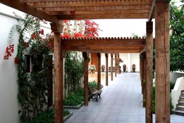
La Hacienda courtyard (Dick Morasch).
The next morning we both felt much better and ate a light breakfast prior to our 6:30 am departure through the Colca Valley to view the Andean condors that typically soar over the canyon walls at 9 am. The temperature was only 30 degrees but skies were sunny and bright. Our first stop was at the schoolyard in Yanque. Each school day the children would dress in traditional costume to perform traditional dances in order to raise money for their yearly end-of the year trip. This year the children were planning to visit Cusco.
COLCA CANYON
The Colca Canyon, regarded as one of the most scenic regions in Peru, remained unexplored until the late 1970's. The canyon forms part of a volcanic mountain range that is more than 62 miles long. The Colca River, which is one of the sources of the Amazon, cuts through the massive canyon that is nearly 11,150 feet deep. Snow-capped volcanoes, narrow gorges, artistically terraced agricultural slopes predating the Incas rising up steep hillsides, and remote traditional villages provide stunning vistas. Descendants of the Collaguas and Cabanas who pre-date the Incas, these villagers maintain their native languages, ancient customs and distinctive traditional dress. Their churches are small but richly decorated. Agriculture is the primary source of income. Many of the local women would set up roadside stands to sell fruit or textiles to tourists.
Traveling along the narrow, winding, dusty, and bumpy road, we reached the Valley of the Condors about 8:30 am. Although there were several viewing areas in which to watch for the condors, Carlos suggested that we move further down the road as condors were often frightened of noise. Within a few minutes we witnessed pairs on condors slowly rising from the depths of the canyons and gradually gaining altitude with each pass before heading out along the river in search of prey. With wingspans of 12 feet, the condors are the largest birds in the world. Because of their size, they are unable to lift off from the ground, instead taking off from cliff perches. There is some concern that the number of resident Andean condors has decreased dramatically within the past several years that may be the result of the rapid hotel development and increased traffic near the canyon. We were fortunate to view approximately 12-14 condors during our visit.
About 11 am, we hiked about a mile along the rim of the canyon. The sun was getting much warmer so we were grateful that the climb was not steep. As Carlos knew several of the local women, we stopped at several of the roadside stands to purchase and taste passion fruit (red, orange and green varieties) or to make souvenir purchases.
We again enjoyed a buffet lunch in Chivay and this time Carlos called ahead and requested that guinea pig be served. We returned to the Colca Lodge close to 3 pm. Altitude continued to be exhausting so while Dick napped, I took a walk down to the river and generally explored the property. Upon my return and feeling the beginning of an altitude headache, I prepared a coca sandwich with a piece of ash acting as the catalyst. That certainly was the cure. Our room was comfortable and rustic with high beamed ceilings and what appeared to be heated flooring. There was no TV or Internet service in the rooms. However, the main lodge did have Internet connectivity. Again, we were both sleeping by 9 pm. Early bedtimes meant that we were unable to enjoy their dinners.
DAY 8 - WEDNESDAY
Jun 06, 2012
The Candelabro (Dick Morasch).
Under a cloudless blue sky, we departed from the Colca Lodge at 8 am for the drive to Puno. During the first half of the drive we retraced our drive thru Chivay and over the 16,100 Patapampa Pass, and then headed east toward Puno with its altitude of 12,566 ft. The highway was paved and well maintained. The landscape varied from dry and flat, to rocky and hilly. Mining was important in this area and many large trucks were on the highway. We stopped at a large lagoon and viewed flocks of Chilean flamingoes. We also passed thru the town of Jilicana that Carlos described as a large wealthy commercial area that dealt in much illegal activity (counterfeit products from Bolivia and drugs). The city appeared dirty and chaotic.
PUNO
Arriving from above the city and descending into Puno was an interesting sight. The center of the town was located near the port. Homes were nestled on hillsides above the city, all facing Lake Titicaca. Most of the downtown area was small and could be seen on foot. The main pedestrian thoroughfare was full of restaurants, shops, and bars, and connected the Plaza de Armas to Parque Pino. The Cathedral located on the Plaza was large but rather plain and dark.
We arrived in Puno at 3:30 pm. Our hotel room was large and comfortable with a television featuring an English news channel. We enjoyed an early dinner with Carlos, Sarah and Christopher. Dick and I both selected delicious grilled kingfish with sides of potatoes and quinoa. Later Dick and I explored the pedestrian thoroughfare, plaza and surrounding area before walking back to our hotel. The streets and sidewalks were very narrow. Three-wheeled taxis were everywhere. Again, stop signs or lights were nonexistent with vehicles announcing their presence at intersections by blowing horns. Again, we were sleeping shortly after 9 pm.
DAY 9 - THURSDAY
Jun 07, 2012
Speeding to Islas Ballestras (Dick Morasch).
LAKE TITICACA
According the local Andean legend, Lake Titicaca was the birthplace of civilization and has long been considered a sacred place among indigenous Andean people who believe powerful spirits live in its depths. It is South America's largest lake and the world's highest navigable body of water. Its deep azure waters seem to stretch forever across the altiplano. The lake has been inhabited for thousand of years with reed boats crossing the lake as early as 2500 B.C. The lake straddles the modern border between Peru and Bolivia.
Following an early breakfast in our hotel, we met our group at 7:45 am and departed for the harbor. The boat carrying approximately 30 passengers and 10 life preservers and maintaining a speed of only three miles per hour, featured indoor covered seating as well as eight seats on the open roof.
UROS FLOATING ISLANDS
Currently, there are 45 floating islands located about three miles from Puno in the Bay of Puno. The Uros Indians of Lake Titicaca made these islands by hand from totora reeds that grow in abundance in the shallow water of the lake. It is believed the Uros Indians created and inhabited the islands upon the arrival of the Spaniards. The islands first came in contact with the world in the 1960's and now they live mostly off tourism.
Our first stop was the Uros Floating Islands. According to our local guide, each island was inhabited by an extended family of approximately 5-6 households units. The island was constructed by reed blocks, including the roots, which were tied together and anchored in the shallow waters with eucalyptus poles. Each year additional reeds were layered on top. Walking on the reeds invoked a soft spongy sensation. If a family had major disagreements with other family units, their hut would be cut off the island and set afloat. Huts were made of reed, and children slept in a small hut next to their parents. School age children attended classes in Puno. Several huts had television sets. Following a demonstration and tour, women immediately brought out their wares to sell, followed by a welcome song sung in four different languages. We purchased a small wall hanging featuring the symbols of the island. The staged commercial aspect was overwhelming and was a huge distraction from an otherwise interesting visit.
AMANTANI ISLAND
Located twenty-two miles northeast of Puno, the circular island is a beautiful but barren and rocky place with about 10 villages composed of about 800 families of farmers, fishers and weavers. Ancient ruins clinging to the island's two peaks, Pachatata and Pachamama (Father and Mother Earth). Ancient looking stonewalls mark the fields and terraces of different communities while cows, sheep and alpacas graze the hillsides.
We then headed further out to our destination of Amantani Island that is located approximately 22 miles northeast of Puno, well outside of the bay. Thank goodness the weather and scenery were beautiful as the trip took about 4 hours. We sat on the top outdoor deck for most of the trip. The only rough water occurred as we exited the bay and moved into the open waters of the lake. Viewed from the lake, Amantani Island was picturesque with its shoreline of red cliffs, sheep grazing on hillsides, and stone fences separating small gardening plots. Families were busy completing the harvest. The women of the families that were expecting to host the tourists for the night were at the small harbor to welcome our arrival.
Olga, our host 'momma' led us up a very steep pathway to her home. Again, the altitude of approximately 12,500 feet had a huge impact on my performance, as I had to rest every minute or so during our climb. However, Dick managed the climb surprisingly well. We later learned that our host family lived at the highest elevation in the community. Carlos was assigned to also stay with our host family, which was fortunate for the purpose of translation.
We arrived at our home for the night at 2 pm. Olga served a tasty lunch of soup with quinoa, potatoes, and other small vegetables. The main course included 3 types of fresh boiled potatoes, sliced fried cow's cheese, and fresh sliced tomatoes and cucumbers. Following lunch, Olga showed us the many traditional hats she had knit. We purchased a brown and white hat for William, and we then gave her the bags of pasta and oil we previously purchased in Puno. Dick and I walked around the outside of the small home and admired the sunflowers, geraniums, snapdragons and many other varieties of plants I could not name. The family had completed the harvest of wheat, quinoa, corn, potatoes and fava beans. A small pen contained sheep and lambs. Powered by solar energy, the home was a small adobe hut with a small inner courtyard. Dirt floors and three rooms serving as family living quarters: kitchen cooking area with fireplace, eating area, and sleeping area. Host families were required to maintain separate sleeping quarters for tourists. Thus our room was an upper level attachment reached by a set of steep, rickety stairs. The room was large with linoleum flooring, two windows, one overlooking the lake, and single beds with many blankets. Two small chamber pots, one pink and one blue, were in the room. Located next to the house was a small outhouse containing a non-flush toilet and sink.
At 3:30 we started the steep climb to the temple of Patchamama, Father Earth, which was located at the top of the highest point on the island. We rested at a large outdoor soccer stadium before completing the hour-long trek. Again the path was narrow, strewn with rocks and very steep. The temple was enclosed by a stonewall and locked gate, that was only opened once per year during the Festival of the Sun to pray for a bountiful harvest. Sunset over the Bolivian Andes was a spectacular blaze of oranges and purples as storm clouds were gathering on the horizon. As we neared our home for the night, it started to rain.
I rested a short time prior to dinner while Dick sat in the dining area with Carlos and the father, who was a fisherman. The couple had two children, Nicole and Erica, ages 4 and 15. Carlos suggested to Olga that she prepare a light meal as our appetites were small (and to not waste food) so she served rice and fried potatoes. At 8 pm, Olga dressed us in traditional clothing in preparation for the celebration and dance at the community center. I wore three layers of skirts, a wide embroidered belt over an embroidered blouse, and a long black shawl covering my head. Dick wore a heavy woven poncho and traditional Peruvian knit hat. Flashlights were used to guide us down the rocky path to the center where a 3-piece musical group played while the villagers and tourists exerted themselves on the dance floor. With the heavy clothing and high altitude, two long dances had us looking for the sidelines. Returning to the house near 9:30 pm, we were treated to the rising of a full golden moon casting shadows over the hills and reflecting on the lake. Temperatures dropped to the low 30's during the early morning hours and the wind whistled through our room.
DAY 10 - FRIDAY
Jun 08, 2012
Humboldt penguin on Lslas Ballestras (Dick Morasch).
With the sun rising over the Bolivian Andes and peering through our window at 6 am, we rose in order to prepare for our departure. Following breakfast of rolls, fried cake and tea, and with many hugs and gracias to the family, Olga again led us down to the harbor.
TAQUILE ISLAND
About 22 miles east of Puno, this small island is stunningly beautiful. Only 1/2 mile wide and 3 1/2 miles long, it rises to a high point of 866 feet above the lake. The rugged ruddy color of the land contrasted with the blue sky and lake, and its hillsides were dotted with Inca stone agricultural terraces and other stone ruins. Known for retaining its traditional customs, the 3,000 inhabitants go about their daily lives without electricity or vehicles. Taquile textiles are some of the finest in Peru.
The boat trip to Taquile Island took about 2 hours. The sky was blue and the waters were calm. Approaching the island, we realized the climb to the plaza would be daunting as we could see the stone-paved path was steep and long. Beautiful views offered numerous photo opportunities and much needed rest breaks. The island's main plaza featured a small church, several small food shops, and a textile cooperative featuring locally made woven hats, sweaters, shawls, and blankets. The men were the knitters in the community and could be seen knitting as they hurried across the plaza. The plaza was rather unattractive compared to plazas in other villages as it was void of plants, benches, or fountains. A brightly painted green and yellow school and small stucco homes with a variety of beautiful flowers were located on paths leading from the plaza. Following a brief talk by our local tour guide, we again walked up a narrow steep path for lunch served outdoors on a lovely patio overlooking the bay. With fresh fish as the main course, we enjoyed grilled trout served with fried potatoes and rice. Inca Cola and Coke were popular beverages. The walk to the boat now on the other side of the island entailed a steep flight of over 550 rock steps descending to the coast.
Although the boat rides were long, the time was enjoyable and passed quickly as we conversed with other tourists from New Zealand, France, and the Netherlands, who shared their travel adventures, including a New Zealander who attends the EAA exhibit in Oshkosh. Some of the travelers completed missionary work or were students. Returning to the hotel near 4 pm, we needed to say good-bye to Carlos for as planned, he was returning to Arequipa. Again, Dick and I rested prior to heading out to dinner. We again walked to the pedestrian mall and ate at Colors, a small and inviting restaurant. I don't recall what we ate, but the piscos sours were great. Following dinner we walked for a short while prior to returning to our hotel and watching CNN.
DAY 11 - SATURDAY
Jun 09, 2012
Bird perched upon the rocky shoreline (Dick Morasch).
The plan for today was an 8-hour bus ride to Cusco featuring numerous stops along the way. Adventure Life again handled our transfer from hotel to bus terminal. We departed the hotel at 6:30 for 7 am departure on the Inka Express. This time we sat at the back of the bus with 5 seats across, the middle occupied by a young student named Sara who was traveling alone but meeting a friend in Cusco. We noted that the buses appeared to be 'open drug markets', as for whatever ailment a tourist described, another tourist would be quick to offer a pill, which was usually happily accepted!
First Stop: Pukara, a small village located on the pampas, was a small dusty village featuring a large Jesuit church built in the 1600's, small museum featuring pottery, textiles, and a mummy.
Second Stop: Les Desea/Feliz Viaje (the highest pass at 14,250). Approaching the pass, large herds of cattle were grazing in the grass-covered valleys. Numerous small villages, several with indoor soccer stadiums, were scattered along the paved highway. Pulling off the road, we were able to view the jagged peaks of the snow-capped Andean mountains. With low hanging clouds, it was noticeably cooler and windy.
Third Stop: In the larger village of Solaris located at 11,515 feet, we stopped for lunch at a local outdoor restaurant that appeared to be a popular tourist stop. Shaded by umbrellas, large tables were setup in a garden setting. Musicians played the traditional pipe music, along with the ubiquitous Simon and Garfunkel songs, while we indulged on a wide variety of fruit, vegetables, meats and desserts served buffet style.
Fourth Stop: The ruins of Raqchi near the small village of San Pedro, looked like a large aqueduct from the road. These ruins are the remains of the Temple of Viracocha, one of the holiest shrines in the Inca Empire. Twenty-two columns made of stone blocks helped support the largest-known Inca roof. Although the Spaniards destroyed most of the structures, the original foundations remain. Numerous remains of houses for nobility and storage buildings were also visible. Large agricultural areas surrounded the ruins.
Leaving the ruins at 2 pm, and continuing our gradual descent, the landscape gradually changed to wide lush agricultural valleys. Cattle and sheep were grazing while the farmers harvested wheat, corn, potatoes and beans. The Urubamba River (Sacred River) flowed through the valley. Gradually the valley narrowed and we began a step climb through hills covered with the bluish green foliage of the eucalyptus trees.
Fifth Stop: The small village of Anyahuaylillas is famous for its lavishly decorated Church that is beautiful with its baroque embellishments of ornate carving and silver and gold. The church was built in the 1600's on top of the Inca temple with indigenous workers painting the murals. During the 1700's when the Dominicans forced the Jesuits to leave, the Dominicans covered the murals with large painted canvases. The church features a large famous canvas of the Immaculate Conception, as well as the two canvases named the Stairway to Heaven and the Stairway to Hell. It is said that local villagers take turns guarding the treasures of gold and silver hidden within the church 24 hours a day.
At 5 pm we arrived at the bus station in Cusco where Teddy Romano, our new tour guide from Adventure Life, welcomed and escorted us to our hotel, the Casa Andina Koricancha. After showering and a brief rest, we walked to the center of Cusco and its beautiful Plaza de Armas. Deciding upon dinner at the Inka Grill that overlooked the Plaza, we enjoyed pisco sours and cerveza with our meal. I ate beef in elderberry wine sauce with potato strata and asparagus, while Dick ate Lomo Saltado. After exploring the plaza and surrounding streets, we walked back to the hotel at 10:15 pm.
CUSCO
Cradled by the southeastern Andean Mountains, Cusco lies at over 11,000 feet above sea level. The city maintains the look and feel of an Andean capital with its blend of pre-Columbian and colonial history as well as its contemporary mestizo culture. Not only being the Inca empire's holy city, it was also the epicenter of the Inca network of roads connecting all points in its empire. After an epic battle at Sacsayhuaman, the Spaniards razed most Inca buildings often rebuilding upon the original foundations. After a devastating earthquake in 1650, it became largely a baroque city with its colonial era and Renaissance churches and mansions.
PLAZA DE ARMAS
The focal point of life in Cusco is the Plaza de Armas that is located in the center of the old city. Anchored by its large central fountain, the plaza is filled with benches, trees, flowers, peddlers selling their wares, tourists and locals. Porticoes lining the sidewalks surrounding the plaza are filled with shops and restaurants featuring carved wooden balconies. La Cathedral and the large Jesuit church are also located on the Plaza.
DAY 12 - SUNDAY
Jun 10, 2012
Relaxing on the rocks (Dick Morasch).
Exploring the Sacred Valley was the plan for the day. Departing from the hotel in Cusco at 8 am, we again rode in a comfortable 11-seat Mercedes van. It was soon evident that tour guide Teddy was quite the opposite from Carlos, meaning a less structured itinerary with later morning departures. About an hour outside of Cusco we stopped at the village of Chinochero to visit the local Sunday Market, colonial church and views of the valley.
CHINOCHERO
The Andean village situated at 12,500 feet featured steep stone steps that climbed through narrow streets lined with brightly colored stucco homes and potted flowers. The main village square contained a massive ancient Inca wall composed of huge rocks with trapezoidal niches overlooking the agricultural terraces. The17th century colonial church made of adobe situated above the square was built on Inca foundations. Faded frescoes covered the exterior walls under the porticoes and mural paintings covered the interior ceiling.
Continuing our drive through the beautiful valley ringed by the snowy peaks of Salcantay, Vilcabamba and the Urubamba mountains ranges in the distance, we continued to see villagers harvesting their crops and shepherds herding their animals. Teddy shared that during the months of December to March, this area receives 65 inches of rain. Community leaders jointly plan the years planting and all villagers work cooperatively. Although unusual, if a family did own a tractor, it was rented out to all villagers. He also stated that only 10% of the land in Peru is available for agriculture. Deciding to take a shortcut to Moray, our driver turned off the paved highway and headed down a narrow, dusty bumpy road. After hitting a deep rut, the van stalled. After several tries and worried exchanged looks, the van did restart and we continued to the site of Moray.
MORAY
This huge depression in the earth caused by erosion and producing intense microclimates was most likely an agricultural development station where Incas tested experimental crops and conditions. Consisting of three main sets of concentric rings that were set deep into the earth, each ring formed sculpted terraces built by layers of gravel, sand, topsoil, and grass. The largest of the three sets had 15 levels with each level being about 10 feet higher than the previous. An elaborate system of irrigation supported each level.
We were stunned by our first view of Moray especially after learning that we would be hiking down into the deep depression. The trail around the upper outer ring followed a gentle decline and while our younger companions did reach the base, Dick and I decided to forego the spiritual energy known to exist at the base, and descended halfway before starting our climb to the top.
Nearing midday, we continued our drive through the Sacred Valley. Descending the valley to the Urubamba River was breathtaking with its steep rolling red hills and snow-capped mountain ranges. Throughout the valley we noticed homes marked by long poles topped by red flags indicating that home-brewed fermented maize beer, or chichi, was for sale inside. A plentiful buffet lunch including chichi was enjoyed in Yucay, a small village along the banks of the river. We decided we preferred Sam Adams to chichi. Continuing our drive, we passed through the larger villages of Urubamba and Yanahuara before reaching our destination of Ollantaytambo.
OLLANTAYTAMBO
This historic town is located at the northwestern end of the Sacred Valley and is the last settlement before reaching Aguas Calientes and Machu Picchu. The snow-capped mountains that embrace the town form a much narrower valley and both sides of the gorge are lined with Inca stone agricultural terraces. The terraced ruins of a massive temple-fortress built by the Incas built into the steep mountainside looms over the town. Ollantaytambo is a grid of streets dating to Inca times and lined with adobe brick walls, blooming bougainvillea, and canals that still carry rushing water down from the mountains.
FORTRESS RUINS
Rising above the valley and town square are dozens of rows of steep stone terraces carved into the hillside. The temple ruins represent one of the Inca Empire's most formidable feats of architecture. After climbing 200 steps to the upper section, you have reached the entry to the temple with its massive doorjam. On the next level are six huge pink granite blocks cut, polished, and fitted perfectly together that form the Temple of the Sun. Across the valley was the quarry that provided the stones for the structure. A great ramp descending from the hilltop ruins was the means by which the Incas transported the massive stones from several miles away.
Upon arrival at the El Sauce Hotel near 3 pm and placing our luggage in our room, Teddy was ready to lead us to the ruins. Viewing the ruins from our hotel was a daunting sight and I entertained thoughts that I would not be reaching the top, or even its midpoint. However, we started our climb and succeeded in reaching the top. In order to avoid most tourists, we walked around the side of the ruins noting the elaborate irrigation system, as well as the storage huts and defensive positions before climbing to the temple areas. After exploring the temple areas, we slowly descended at dusk and returned to the hotel. After a brief rest, Dick and I wandered the dusty quiet streets seeking food and drink. We enjoyed two cervazas at a small quiet bar. Unfortunately, Dick took a slight tumble down the steep, dark and narrow steps. Luckily, he only sustained a slight bruise and cut on his elbow. We crossed the road to the only observed open restaurant where we devoured a wood oven pizza. Returning to our hotel, we set the alarm for 5:30 am and fell asleep.
DAY 13 - MONDAY
Jun 11, 2012
A gathering of birds (Dick Morasch).
Following breakfast and storing our luggage in the hotel, we took a short taxi ride to the train station for the 1.5-hour ride to Aguas Caliente. The PeruRail train, which was very clean and comfortable, followed the course of the rapidly descending Urubamba River through narrow valleys and towering mountains.
AGUAS CALIENTE
Unofficially the base camp for Machu Picchu, this small town is full of souvenir shops, hotels, and restaurants. The Peruvian and local government is now joining forces to improve its infrastructure by paving the roads near the river, train and bus station. The cobblestone roads are very steep with few vehicles. The town is relatively prosperous based on tourism.
Arriving in town, we checked our luggage at the El Mapi Hotel, walked a short distance to the bus station and began the 25-minute ride to Machu Picchu. The road followed a series of switchbacks and hairpin turns through the massive tree covered mountains. A shortcut consisting of stone steps allowed for the more adventurous to forego the $8 bus fare and walk to the top - we choose the bus ride.
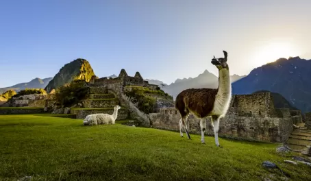
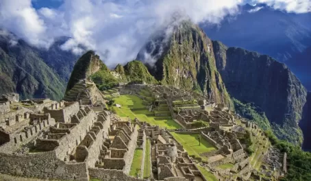
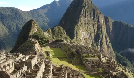
MACHU PICCHU
Invisible from the Urubamba Valley below, and cradled at the center of a radius of Andean peaks at 8,000 feet above sea level, Machu Picchu remains one of the world's great examples of landscape art. Steep terraces, gardens, granite and limestone temples, staircases and aqueducts appear to be carved directly out of the hillside. Forms echo the very shape of the surrounding mountains, and windows and instruments appear to have been constructed to track the sun during the June and December solstices. The only major Inca site not destroyed by the Spanish in the 16th century, many of its architectural features remain in excellent condition.
Teddy suggested we take two short hikes and tour the ruins later in the afternoon after the crowd of tourists had departed. The first hike was to the Sun Gate that followed the usual steep rock path. Dick and I were more than happy to view the ruins from the midpoint as the air was thin and the sun hot. We enjoyed the view while sitting in the shade and snapping pictures. Both Sarah and Christopher climbed to the gate, another 20 or 30 minutes further up the trail. We then discovered the descent was more difficult then the ascent. The next hike was to the Inca Bridge. Although initially a very steep climb, the trail leveled and at some points resembled a trail through a tropical cloud forest. We observed orchids, bromeliads, bird of paradise, wild strawberries, begonias, and numerous other plants along the trail. Birds were plentiful. Although the trail was narrow with steep drop-offs, we did complete the hike and were glad we did.
At 2:30 we ate ham and cheese sandwiches at the only concession facility on site before starting the tour of the Machu Picchu ruins. Being extremely knowledgeable and familiar with the ruins, Teddy led us through the ruins identifying the temples, residential, and agricultural areas. Steep difficult climbs were well rewarded with magnificent views. Exhausted, we left the site at 5:30 and return by bus to Aguas Caliente and to the hotel. Following a few cervazas and dinner at the hotel bar and restaurant, we were sleeping by 9:30 pm.
DAY 14 - TUESDAY
Jun 12, 2012
Bird perched upon the rocky cliffs (Dick Morasch).
We set our alarm for 4:30 am as Dick and I planned to catch the 5:30 am bus to witness sunrise at Machu Picchu. At the bus station, seven buses were lined up to begin ferrying tourist to the ruins. Arriving at 6:10 am, we selected a spot near the trail to the Sun Gate to wait the arrival of the sun. Although low-hanging clouds normally shroud the ruins, the sky was clear with only a scattering of high clouds. Temperatures were in the low 40's with a slight breeze. Near 7:50 am the sun appeared over the tops of the surrounding mountains. It was a beautiful sight to watch the sun slowly wash over the ruins. Dick and I slowly descended to the ruins, stopping to rest and to enjoy the view from the storage huts. Near the Temple of the Condor, we found a protected grassy area overlooking the river far below. Here we rested and took in the view before returning to Aguas Caliente at 10 am. After refreshing ourselves in the hotel, Dick and I relaxed alongside the rapids on the Urubamba River. We found a small restaurant and enjoyed a great wood oven pizza and cold cervaza prior to meeting up with our group for the 1:30 pm return train ride back to Ollantaytambo.
With our driver meeting us at the train station, we quickly retrieved our luggage from the El Sauce Hotel and started the return trip to Cusco. The steep climb from the Urubamba River to the highlands again was breathtaking as the sun was low in the sky. Shadows were long and colors subdued. Returning to the Casa Andina Hotel in Cusco, we showered and rested prior to setting out to a wine and tapas bar for a light meal. The tapas bar was not crowded so in addition to a great variety of foods, the friendly bartender provided the entertainment. Both Peruvian and Chilean wines were served along with a huge selection of tapas. Dick finished the night enjoying a nightcap of a pisco liquor.
DAY 15 - WEDNESDAY
Jun 13, 2012
Fishing boats on the bay (Dick Morasch).
The plan for today was a walking tour of the city to be led by Teddy. Starting at 9:30 am, our first stop was Qoricancha and Santa Domingo, which was located about two blocks from our hotel. Following a tour of the inner courtyards and a peek into the closed chapel, we toured the outside curved wall and admired the spacious gardens. Santo Domingo was perched high above the Ave del Sol and provided a beautiful sight as it was surrounded by lovely terraced gardens featuring flowering hydrangeas, calla lilies, salvia, begonias, lantas and other exotic plants.
QORICANCHA (TEMPLE DEL SOL) AND SANTO DOMINGO
Together Qoricancha (Temple del Sol) and Santo Domingo form the most vivid illustration in Cusco of the clash between Andean and Western Europe. One of the most elaborate temples in the Inca Empire and the culmination of its naturalistic belief system, it was home to 4,000 of the highest-ranking priests and their attendants. Dedicated to the worship of the sun, it contained hundreds of gold panels lining the wall, life-size gold figures, solid gold altars, and a huge golden sun disc, which reflected the sun and bathed the courtyard in sunlight. It was also the primary astronomical observatory for the Incas. After the Spaniards ransacked the temple and removed the gold, the highly polished stones walls were used as the foundations of the Convent of Santo Domingo, which was constructed in the 17th century. The inner courtyard was influenced by mudejar design with it openness, arches, tiles, murals and colors. The 20-foot curved wall forming the foundation still remains despite numerous earthquakes, and may be the greatest example of Inca stonework.
We then walked through the streets congested with both people and vehicles toward the central market located just outside the walls of the center city. Sights and smells were less than pleasant and we were happy to leave. Teddy stated that city officials wanted to tear down the market due to cleanliness and health concerns, but after local protests the plan was withdrawn.
Walking by the Cusco School of Art, we did stop to watch the students construct elaborate paper mache floats to be used for the Corpus Christi festival scheduled for the following Saturday. We then realized that a large number of local people were headed toward the Plaza del Armas so we followed them to find out what was happening. Closed to vehicles, groups of traditionally dressed secondary school aged students were marching around the plaza prior to performing song and dance arrangements before judging booths located in front of the Cathedral. Stopping to watch was great fun and provided a good rest before heading to the ruins above the city.
SACSAYHUAMAN
Usually referred to as a garrison or fortress because of its massive limestone walls, it is believed that Sacsayhuaman served as a religious temple despite its military significance. The Inca emperor Pachacute began the site's construction in the mid 15th century, and it took nearly 100 years and many thousands of men to complete it. The massive blocks of limestone that fit together perfectly without the use of mortar were constructed in a zigzag formation of three tiers. One of the blocks is 11 feet tall and is estimated to weigh 300 tons. Some of the limestone and other stones were brought from as far as 20 miles.
Foregoing the walk under the bright noontime sun, we took a short taxi ride to Sacsayhuaman. After walking around the large flat area of the ruins and admiring the massive and precise stonework, we stopped to view the layout of the city stretched out far below. Dick and I then returned to the city by taxi where we enjoyed lunch at the Lima restaurant overlooking the Plaza. I enjoyed an adobe pork shoulder dish with sweet potatoes while Dick ordered his favorite, the Lomo Saltado, which is strips of beef tenderloin with fried onions, potatoes and tomatoes served over rice. I also had a refreshing coconut and lime drink while Dick stayed with a cerveza.
At 3 pm we rejoined our group and continued our tour up the steep and narrow cobblestone streets to the neighborhood of San Blas. Here we stopped at artist studios as well as shops featuring elaborate geometrical woven textiles. We purchased a small watercolor painting from a local artist who proudly produced a newspaper article featuring his show in NYC.
LA CATEDRAL
Started in 1559 and taking almost 100 years to complete, La Catedral sits on the foundation of an Inca Palace and was built using blocks taken from the ruins at Sacsayhuaman. Built in the Renaissance style and now restored, La Catedral contains over 400 canvasses that were painted between the 16th and 18th centuries. It also contains the oldest surviving painting in Cusco that shows the entire city during the earthquake of 1650. The inhabitants can be seen parading around the plaza with a crucifix praying for the earthquake to stop, which it did. This precious crucifix is called El Senor de los Temblores, or Lord of the Earthquake. Weighing over 885 pounds, the main alter is fashioned from silver mined in Bolivia and features the patron saint of Cusco. There are also many silver and gold side chapels with elaborate altars that contrast with austerity of the buildings stonework. During festival times, La Catedral is filled with pedestals supporting larger than life statues of saints, surrounded by thousands of candles and bands of musicians honoring them.
Our final stop was La Catedral located in the Plaza. Teddy led us through the three ornate chapels now covered in elaborate gold leaf after the Spaniards removed the gold. Local indigenous craftsmen completed the ornate cedar woodcarvings in the large choir stall. Statues, with downcast eyes, were garbed in bright robes or blankets highly embellished with beading or decorative woven trim. These statues were brought from local churches in preparation for the upcoming Corpus Christi festival. Local artists who were trained by the Dominicans completed the large paintings that hung on the walls. We also viewed El Negrito Christ, also known as the Lord of the Earthquake, as well as the Last Supper that depicts the apostles drinking chichi and Judas holding a bag of gold.
Returning to our hotel at 6 pm, we said goodbye to Teddy. Near 7 pm we decided to take a final nighttime walk around the Plaza prior to our departure the following day. The evening air was definitely chilly so we happily stopped in a welcoming Italian restaurant where we had a great time over pizza and cervaza. We marveled at the well-dressed older Italian gentleman who was doing a remarkable job gently leading those passing by into the establishment.
DAY 16 - THURSDAY
Jun 14, 2012
Exploring the Paracas National Reserve (Dick Morasch).
Following a leisurely breakfast Dick and I started a final walk around Cusco. We stopped in several small shops and made a few small purchases. We walked by Santo Domingo and down the busy Ave del Sol. Returning to the Plaza de Armas, we enjoyed watching the senior citizens whose turn it was to perform before the judges in front of the Cathedral. Finally we returned to the hotel for our 12:20 departure to the airport.
The flight home was uneventful but long. Leaving Cusco at 2:30 pm on LAN airlines, we arrived in Lima at 3:55 pm. After retrieving our bags, we found a table in the large departure area outside the secure area and prepared to wait until 8 pm for check-in with United for the 11:59 pm flight to Houston. Unfortunately, we purchased a bottle of pisco at the duty free store that was promptly confiscated from my carry on bag at the Houston TSA checkpoint. Arriving in Houston at 6:21 am, clearing customs, retrieving and rechecking luggage, and clearing TSA security, we arrived at the departure gate for Washington Reagan National Airport with only minutes to spare prior to departure at 7:35 am.
Our fabulous Peru adventure concluded with our arrival in Washington at 11:39 am where Sara, Gavin and Ellie greeted us. It was good to be home welcomed by smiles and wags!
Great company. Good communications. Great accommodations, excursions, transport. Guide Elvira was spectacular along with transport, driver, Cesar and activities
Kathy S
4 weeks ago
Everything is streamlined so far. It seems that tour is property planned and there would be no surprises.
Apjeet Singh Button
1 month ago
Jess from Adventure Life and her colleague Petchie have been wonderful to work with. Very responsive and helpful as we are planning our trip to Machu Picchu and the Galapagos
Hans
5 months ago
Clara Tort has been our Travel Advisor for Buenos Aires, then for Iguazu, then for Mendoza and Aconcagua Trekking, and then for Patagonia and Fitz Roy trekking. She has navigated with us through our travels, and now we are coming back for more- onto Machu Pichu and Peru.
Gus ORDONEZ
6 months ago
We have used AL for decades now to plan trips. Kassandra has been with us from the start and has never disappointed. She knows our family and our quirks and is always willing to fit the trip to us. This time we made her work for the booking because of family member schedules. It has all come together for a great Christmas gift for many families.
Kris Rowe
6 months ago
Great company. Good communications. Great accommodations, excursions, transport. Guide Elvira was spectacular along with transport, driver, Cesar and activities
We use cookies to give you the best experience on our website. Continue browsing the site if you're ok with this. For more info, please see our privacy policy.